'%3e%3cpath%20d='M34.1406%205.85938C30.3906%202.10547%2025.3047%200%2020%200C14.6953%200%209.60938%202.10547%205.85938%205.85938C2.10938%209.61328%200%2014.6953%200%2020C0%2025.3047%202.10547%2030.3906%205.85938%2034.1406C9.61328%2037.8906%2014.6953%2040%2020%2040C25.3047%2040%2030.3906%2037.8945%2034.1406%2034.1406C37.8906%2030.3906%2040%2025.3047%2040%2020C40%2014.6953%2037.8945%209.60938%2034.1406%205.85938ZM37.0117%2023.543H31.1602V13.5391H27.6328V19.9414C28.1211%2020.6914%2028.3711%2021.582%2028.3711%2022.5625V22.625C28.3711%2023.668%2028.1172%2024.6055%2027.6328%2025.4297V26.6094H36.082C33.4883%2032.9375%2027.2891%2037.3789%2020.0039%2037.3789C10.3711%2037.3789%202.62109%2029.6289%202.62109%2020C2.62109%2010.3711%2010.3711%202.62109%2020%202.62109C29.6289%202.62109%2037.3789%2010.3711%2037.3789%2020C37.3789%2021.1484%2037.2617%2022.2656%2037.0508%2023.3477C37.0391%2023.4141%2037.0234%2023.4766%2037.0117%2023.543Z'%20fill='white'/%3e%3cpath%20d='M22.3086%2018.5352C20.4336%2018.125%2019.9531%2017.8398%2019.9766%2017.1836V17.1406C19.9766%2016.6992%2020.3477%2016.2148%2021.4023%2016.2148C22.582%2016.2148%2023.8867%2016.6797%2025.0781%2017.4766L26.8516%2015.0195C25.4453%2013.8906%2023.707%2013.3398%2021.5547%2013.3398C18.5195%2013.3398%2016.4375%2015%2016.4063%2017.4766V17.5352C16.3633%2020.2617%2018.5859%2020.9805%2021.293%2021.6016C23.0391%2021.9766%2023.5703%2022.3164%2023.5703%2022.9609L23.5469%2022.9766C23.5469%2023.3906%2023.2578%2023.7031%2022.7852%2023.8359C22.5742%2023.9062%2022.1289%2023.9727%2021.5156%2023.9727C20.7617%2023.9727%2019.7539%2023.8633%2018.6328%2023.4844C18.0898%2023.2891%2017.4727%2023.0039%2016.8047%2022.6133L20.1406%2026.625C20.2813%2026.6602%2021.0977%2026.8516%2021.7734%2026.8516C25.0039%2026.8516%2027.0859%2025.2461%2027.1094%2022.6328V22.5703C27.1602%2020.1133%2025.2148%2019.1719%2022.3086%2018.5352Z'%20fill='white'/%3e%3cpath%20d='M5.24219%2013.5664V26.6133H8.75391V23.7578L10.2969%2021.9531L14.2031%2026.6133H18.3867L12.3555%2019.5195L17.4023%2013.5664H13.4531L8.75391%2019.0586V13.5664H5.24219Z'%20fill='white'/%3e%3c/g%3e%3cdefs%3e%3cclipPath%20id='clip0_97_2430'%3e%3crect%20width='40'%20height='40'%20fill='white'/%3e%3c/clipPath%3e%3c/defs%3e%3c/svg%3e)




Estimated read time: 4-5 minutes
- Remnants of Hurricane Rachel are expected to bring heavy rain to Utah, providing potential drought relief.
- Meteorologists warns of potential flooding risks, too.
- Heavy rainfall can help improve soil moisture before upcoming winter's snowpack.
SALT LAKE CITY — Utah could be in for heavy rainfall over the next several days as remnants of what was Hurricane Rachel are forecast to collide with a strong system from the Pacific Northwest this weekend.
Models suggest that multiple inches of rain are possible between this weekend and early next week, which could lead to new flooding threats, but figures to be good for the drought-stricken state.
"Obviously, the potential for flooding is not anything we want to see, but in terms of the moisture, it's a great time to get our soil moisture healthy," said Hayden Mahan, a meteorologist for the National Weather Service in Salt Lake City.
Storm timing
Hurricane Rachel began forming in the Pacific Ocean late last month, reaching hurricane status on Sept. 30. It maxed out at Category 2, causing flooding in Mexico, and has been churning off the country's coast for several days as a tropical storm.
It's forecast to remain a tropical storm as it moves northeast toward southern California, and then ultimately Arizona and Utah, as it's drawn to the states by southwest flow in the area, per the National Hurricane Center.
Its outlook suggests that it will be a tropical depression or post-tropical depression by the time it arrives in the Beehive State.
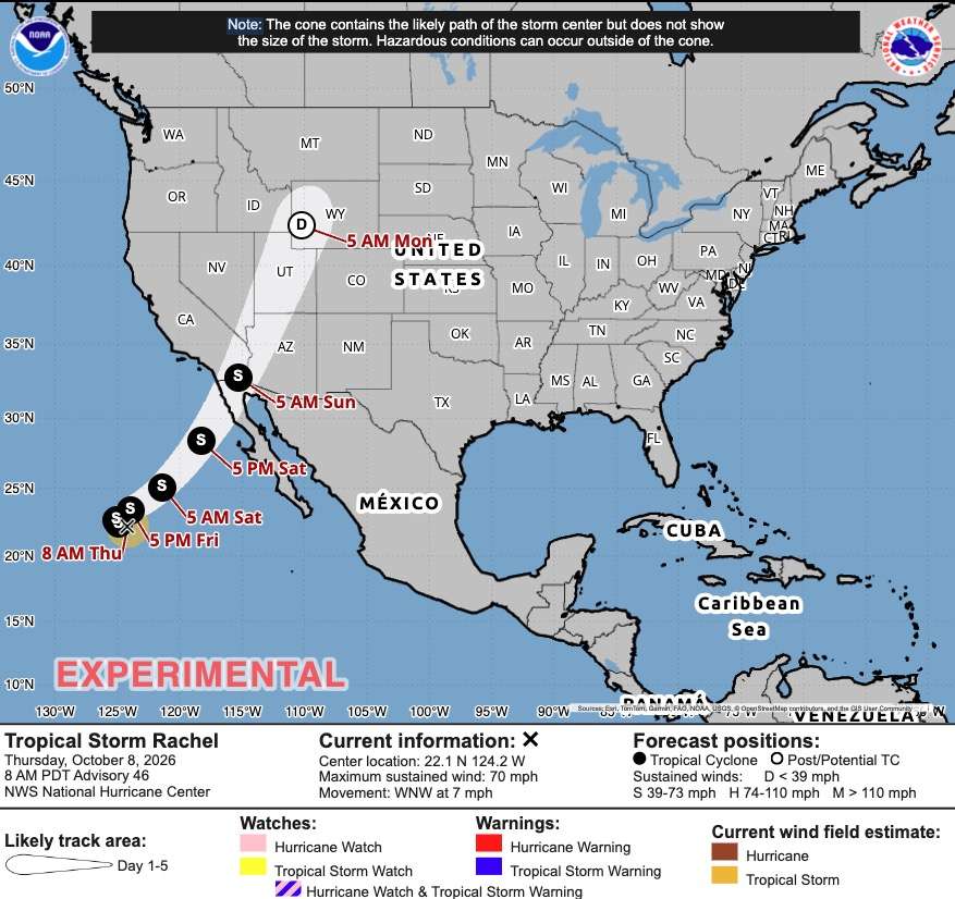
At the same time, a low-pressure system is sliding down the Pacific Coast from Alaska, fueling storm activity in the west, according to KSL meteorologist Matt Johnson. Some pop-up showers are possible to close out the workweek, especially in the mountains, but storms will become more widespread by Saturday afternoon, as the two systems interact.
More statewide activity is expected on Sunday, as the core of the low-pressure system reaches California and Rachel continues its northern push.
"We are talking about the potential for heavy rain with this," Johnson said.
Widespread rain is forecast to continue into the next workweek. As Rachel moves through Utah, the core of the Alaska low-pressure system is expected to begin moving east, cutting through southern Utah before moving northeast as it passes through the state on Wednesday.
Strong rain probabilities are forecast for most of the state on Monday, Tuesday and Wednesday, with additional moisture lingering into Thursday. Cooler air may also produce more mountain snow, following the first brushing last week, Johnson said.
Possible accumulations
It's not terribly uncommon for Utah to receive remnants from tropical storms or hurricanes. In 2023, Utah even received remnants of two storms — Hilary and Harold — within the same week.
These storms have the potential to bring strong moisture, as models suggest for the next week.
Many mountain areas have the potential to receive three inches of precipitation or more by Wednesday night, per KSL Weather models. Many communities across southern, central and northern Utah, including St. George, Salt Lake City and Logan, could also end up with 1.5-2 inches or more of rain over that time.
About half to two-thirds of that could fall by mid-Monday. Those projections, Johnson said, are based on the average of various modeling systems, which means it could be higher or lower than what's projected as of Thursday.
Where Rachel goes as it moves toward Utah will factor into the exact totals. Models also suggest some areas could deal with shadowing, which is why communities like Fillmore are currently projected to receive less than an inch of rain over the next week.
Storm impacts
All of that moisture in a short amount of time could lead to flooding. The National Weather Service has been meeting with various other entities on whether to issue a flood watch ahead of Rachel's arrival, Mahan told KSL on Thursday.
Sunday and Monday are when the strongest potential for flooding is expected, especially as Rachel moves through the state.
The weather service typically issues flood warnings when radar shows enough rain is falling over a flood-prone area. Traditional flood-prone areas include slot canyons, normally dry washes and slickrock areas, which are common within Utah's national and state parks, as well as recent burn scars.
Urban flooding is also a potential risk just because of the potential rainfall totals, Mahan said.
"We're going to have to keep an eye on places like urban areas and even main stem rivers that could see a lot of water and potentially flash flooding issues," he said.
However, the storm has the potential to help out Utah's drought situation, which has improved in recent weeks. Over 75% of the state remains in severe or extreme drought, down nearly 10 percentage points from last week and almost 20 below three months ago.
The storm won't significantly boost reservoirs, but it can still boost the state's hydrology. Soil moisture levels in the mountains remain slightly above-normal for this point in the year, and the added boost can help improve snowpack runoff efficiency in the spring.
Snowpack accounts for approximately 95% of the state's water supply.
"(It's) definitely important," Mahan added. "This is actually a great time to see this amount of moisture."
Full seven-day forecasts for areas across Utah can be found online at the KSL Weather Center.