'%3e%3cpath%20d='M34.1406%205.85938C30.3906%202.10547%2025.3047%200%2020%200C14.6953%200%209.60938%202.10547%205.85938%205.85938C2.10938%209.61328%200%2014.6953%200%2020C0%2025.3047%202.10547%2030.3906%205.85938%2034.1406C9.61328%2037.8906%2014.6953%2040%2020%2040C25.3047%2040%2030.3906%2037.8945%2034.1406%2034.1406C37.8906%2030.3906%2040%2025.3047%2040%2020C40%2014.6953%2037.8945%209.60938%2034.1406%205.85938ZM37.0117%2023.543H31.1602V13.5391H27.6328V19.9414C28.1211%2020.6914%2028.3711%2021.582%2028.3711%2022.5625V22.625C28.3711%2023.668%2028.1172%2024.6055%2027.6328%2025.4297V26.6094H36.082C33.4883%2032.9375%2027.2891%2037.3789%2020.0039%2037.3789C10.3711%2037.3789%202.62109%2029.6289%202.62109%2020C2.62109%2010.3711%2010.3711%202.62109%2020%202.62109C29.6289%202.62109%2037.3789%2010.3711%2037.3789%2020C37.3789%2021.1484%2037.2617%2022.2656%2037.0508%2023.3477C37.0391%2023.4141%2037.0234%2023.4766%2037.0117%2023.543Z'%20fill='white'/%3e%3cpath%20d='M22.3086%2018.5352C20.4336%2018.125%2019.9531%2017.8398%2019.9766%2017.1836V17.1406C19.9766%2016.6992%2020.3477%2016.2148%2021.4023%2016.2148C22.582%2016.2148%2023.8867%2016.6797%2025.0781%2017.4766L26.8516%2015.0195C25.4453%2013.8906%2023.707%2013.3398%2021.5547%2013.3398C18.5195%2013.3398%2016.4375%2015%2016.4063%2017.4766V17.5352C16.3633%2020.2617%2018.5859%2020.9805%2021.293%2021.6016C23.0391%2021.9766%2023.5703%2022.3164%2023.5703%2022.9609L23.5469%2022.9766C23.5469%2023.3906%2023.2578%2023.7031%2022.7852%2023.8359C22.5742%2023.9062%2022.1289%2023.9727%2021.5156%2023.9727C20.7617%2023.9727%2019.7539%2023.8633%2018.6328%2023.4844C18.0898%2023.2891%2017.4727%2023.0039%2016.8047%2022.6133L20.1406%2026.625C20.2813%2026.6602%2021.0977%2026.8516%2021.7734%2026.8516C25.0039%2026.8516%2027.0859%2025.2461%2027.1094%2022.6328V22.5703C27.1602%2020.1133%2025.2148%2019.1719%2022.3086%2018.5352Z'%20fill='white'/%3e%3cpath%20d='M5.24219%2013.5664V26.6133H8.75391V23.7578L10.2969%2021.9531L14.2031%2026.6133H18.3867L12.3555%2019.5195L17.4023%2013.5664H13.4531L8.75391%2019.0586V13.5664H5.24219Z'%20fill='white'/%3e%3c/g%3e%3cdefs%3e%3cclipPath%20id='clip0_97_2430'%3e%3crect%20width='40'%20height='40'%20fill='white'/%3e%3c/clipPath%3e%3c/defs%3e%3c/svg%3e)




Estimated read time: 3-4 minutes
- Ski Utah launches a lighthearted campaign supporting El Niño's impact on snowpack.
- The campaign follows last year's record-low snowpack, which drastically affected skier visits.
- Free lawn signs will be distributed Oct. 2 at Ski Utah's Salt Lake City office.
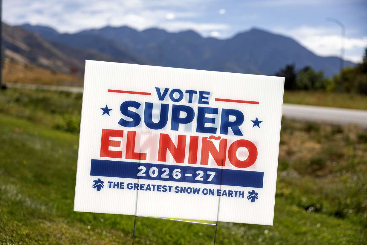
PARK CITY — A mysterious campaign sign planted in front of Deer Valley Resort this month may just sum up a candidate many skiers, snowboarders, water managers and any other fans of snowpack can stand behind.
El Niño.
Specifically, this year's forecasted "super El Niño."
"Vote Super El Niño 2026-2027," it reads. This sign turns out to be part of a new campaign led by Ski Utah, hoping that the oceanic pattern can deliver a robust snowpack that makes up for the record-low snowpack that La Niña left during the 2025-2026 winter.
The nonprofit that markets Utah's public ski and snowboard resorts plans to make these available for lawns everywhere beginning next week, supporting a candidate they believe can unite the state.
"This is the one race where all of Utah is on the same ticket," said Nathan Rafferty, president and CEO of Ski Utah, in a statement. "Whatever divides us the rest of the year, we can all agree on hoping for a big winter."
El Niño, when the Pacific trade winds weaken and allow warm ocean water to move toward the American coast, has already emerged in the Pacific Ocean. National Weather Service Climate Prediction Center officials reported earlier this month that there's more than a 90% chance of "a very strong event" this fall and winter, dictating weather events in North America this fall and winter.
This typically causes the Pacific jet stream to set up closer toward the American Southwest, creating wetter conditions in the region, while warmer and drier conditions emerge in the Pacific Northwest.
Utah is usually caught between El Niño and La Niña, receiving almost an equal mix of above-normal, normal and below-normal precipitation regardless of the pattern. The National Weather Service offered a breakdown of some of the past few strong El Niño winters earlier this month, highlighting this wide range.
For instance, the 1982-1983 and 1997-1998 winters remain two of the best winters on record in terms of statewide snowpack, 133% to 160% of normal. But then there's the 1963-1964 winter, which remains Utah's third-driest winter in over a century's worth of data collection.
The prediction center's preliminary meteorological winter long-range outlook, updated last week, lists Utah as having "equal chances" when it comes to temperature and precipitation, likely because of this history.
That means there's no clear signal whether this winter's precipitation will be wetter, drier or near normal or if its temperatures will be warmer or cooler than normal. The latter played a large role in Utah's record-low snowpack last year because temperatures were so drastically above normal.
It will release its final outlook in November, but others have been more hopeful. Open Snow meteorologist Alan Smith listed Utah and most of the Great Basin as having stronger odds for above-normal snowfall in an outlook released in August.
He believes Utah's strongest months will be January through March, although northern Utah could have above-normal temperatures.
Utah's ski resorts — and its patrons — have been closely monitoring these forecasts, Rafferty said.
They're hoping that this winter will deliver, especially after how rough last year was. Many resorts closed early after June-like temperatures emerged in March, while overall skier visits dropped 26% from the previous season.
Rafferty said election season can often feel divisive, but skiers and snowboarders are usually united in the lift line. Approximately 95% of the state's water supply is tied to mountain snowpack collection, uniting more than just those who ski.
Ski Utah made the political signs as a lighthearted way to mix in all the El Niño talk this election. The organization will be handing out free lawn signs at its headquarters parking lot, 2749 E. Parleys Way in Salt Lake City, from 10 a.m. to 2 p.m. on Oct. 2.
"These signs are a fun way for the local community to show their stoke for the season ahead and celebrate the community that makes winter in Utah so special," Rafferty said.