Estimated read time: 4-5 minutes
This archived news story is available only for your personal, non-commercial use. Information in the story may be outdated or superseded by additional information. Reading or replaying the story in its archived form does not constitute a republication of the story.
- Salt Lake City has received just 6.3 inches of snow this season, fewer than New Orleans' got this week.
- Utah's valleys are experiencing below-average snowfall due to differing weather trends.
- Experts say the trends can still change, pointing to the region's variability.
SALT LAKE CITY — A rare winter storm has turned the South into an unlikely winter wonderland this week.
New Orleans received 8 inches of snow at its airport on Tuesday, while other parts of the region ended up with about a foot of snow, the National Weather Service reported. Impressive snowfall totals were also recorded all across the Gulf Coast as the storm is boosted by a polar vortex that is still blasting most of the U.S. with frigid temperatures.
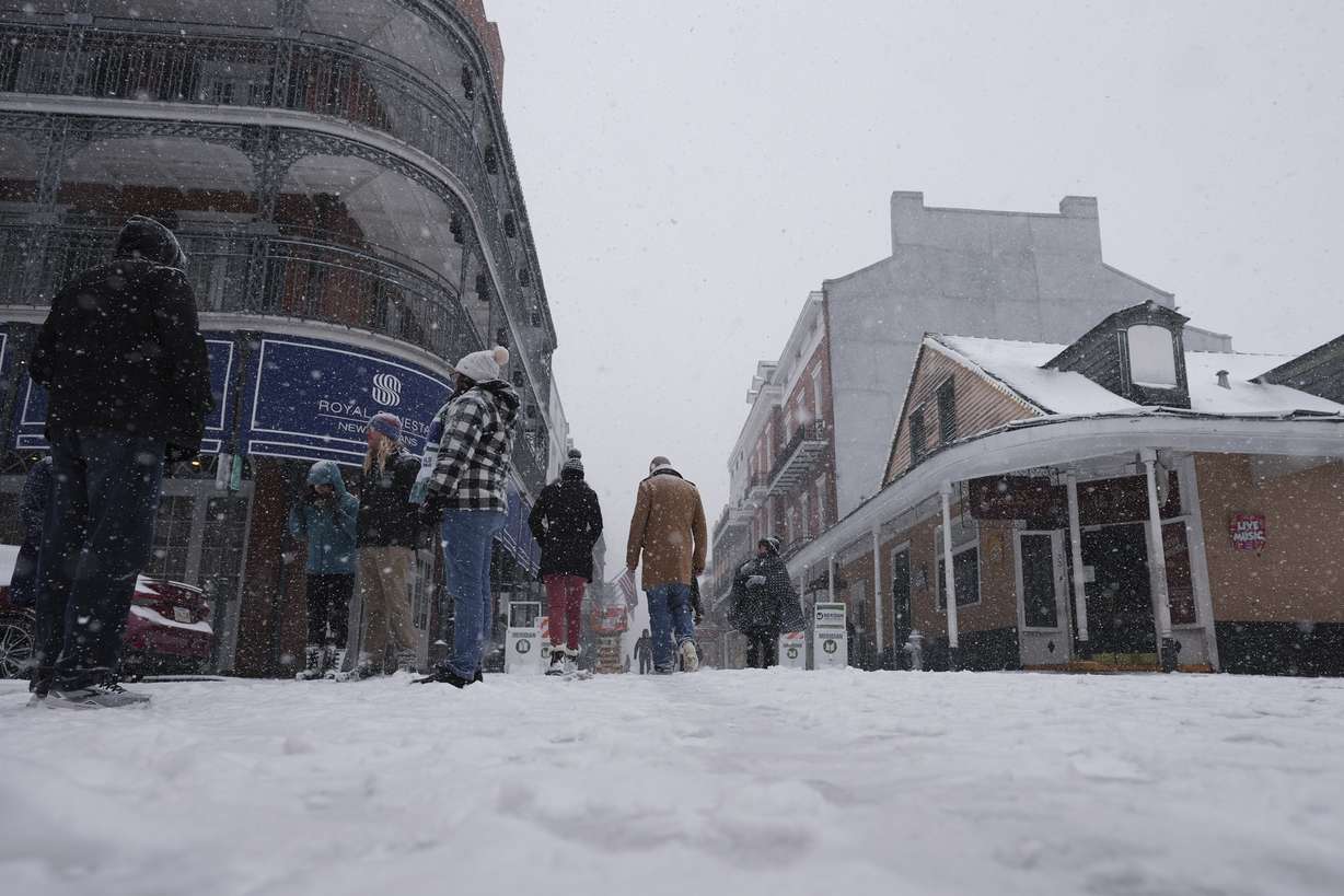
The scenes are a stark contrast to cities across Utah, which are better known for snow but have hardly seen any this season. New Orleans received more snow this week than Salt Lake City has received all season — and that's not even the most interesting stat meteorologists can find.
"At this point, New Orleans has had more snowfall this season than Flagstaff (Arizona), and Flagstaff averages over 90 inches of snow per year," said Alex DeSmet, a meteorologist at the National Weather Service's Salt Lake City office.
But, yes, Salt Lake City — as of Wednesday — has only received 6.3 inches of snow since the start of the water year on Oct. 1, 2024. That's nearly a foot disparity from this point in the season last year and nearly 2 feet below the normal for late January, according to weather service data.
There hasn't been much accumulation even when it has snowed, either. A storm that delivered 1.6 inches of snow on Jan. 4 spared the city from breaking a record for the latest into the season it has received a storm of at least 1 inch of snow. The weather service, adding this all up, notes that Salt Lake City is on pace to have the six-lowest seasonal snowfall total since records were first kept in 1874.
Utah's capital city is not alone in this. Some Utah cities have collected more than others, but snow totals are running well below normal in the valleys this season:
- Cedar City: 15.2 inches (October-January normal: 32.3 inches).
- Tooele: 14.4 inches (October-January normal: 38.6 inches).
- Logan (KVNU site): 11.9 inches (October-January normal: 25.6 inches).
- Fillmore: 11 inches (October-January normal: 31.5 inches).
- Provo: 4.2 inches (October-January normal: 25.4 inches).
Flagstaff's low totals show how much this trend has impacted other cities outside of Utah.
Where is the valley snow?
This year's valley snow deficits have everything to do with a mixture of three common patterns that have rotated since October, DeSmet explains.
Storms in October, December and early January generally tapped into air from the southwest, keeping most storms warm enough that rain didn't transition into snow many times at valley levels — with a few exceptions. Salt Lake City has received 1.63 inches of precipitation since Dec. 1, but only 5.3 inches of new snow in that time.
Recent storms, such as the polar vortex, mirrored trends in November, where the cold fronts came in from western Canada, bringing air cold enough for snow but very little in terms of moisture for snow to fall.
High-pressure systems that block out storms are the third trend. Salt Lake City had a strong inversion at the start of December while storms bounced over the state and into the areas north of it. That broke apart later in the month, but the storm track since Dec. 23 has favored Utah's northern half, leaving southern Utah dry since Thanksgiving.
DeSmet points out that this isn't uncommon for Utah or the West, where the region's precipitation variability make the normal a middle point between extremes.
"It's kind of a hallmark for the West," he said.
In Salt Lake City's case, only 1938, 2003, 1891, 1943 and 1934 had slower starts to the snow collection season by this point in it. The caveat is storms have at least been "productive" for the mountains in northern Utah, which means more for the state's water supply, DeSmet adds.
About 95% of the state's water supply comes from mountain snowpack and the spring snowmelt period. Utah's average mountain snowpack, as of Wednesday, has slipped to 83% of the median average for this point in the year.
It's better in northern Utah, where basins are still running 80%-100% of the median averages, while some basins in central Utah have fallen to below 60%. They're as low as 24% in southwestern Utah.
What about the rest of winter?
The season is far from over, though. Salt Lake City typically stops receiving snow after mid-April, but it has snowed as late as June 6 on record.
Trends can also change in the variable West.
It's really too early to say if snow lovers in the valley will get their wish or not.
–Alex DeSmet, meteorologist
Of the five years with slower starts than this season in Salt Lake City, only two ended up remaining in the Top 10 worst snowfalls in the city's record book, including 1933-1934, which set the record seasonal low at 14.3 inches. The 1937-1938 season, which had a record-low 1.4 inches of snow by Jan. 22, was not one of them, after receiving 28.4 inches of snow after Jan. 22.
A storm is projected to give some minor precipitation statewide this weekend, but long-range outlooks seem to still favor wetter conditions in northern Utah over southern Utah to close out the season. Only time will tell if it boosts valley snow totals.
"What we don't know is if that will look like valley rain events or not," DeSmet said. "It's really too early to say if snow lovers in the valley will get their wish or not."

