
- Flood watches issued in southern and central Utah due to stormy weather in forecast.
- National Weather Service warns of 2-3 inches of rain in some areas, causing potential flash floods.
- Storms expected to impact Wasatch Front later, with snow levels dropping Friday.
SALT LAKE CITY — A series of flood watches have been issued across most of southern and central Utah, as another storm system could produce strong precipitation for the drought-stricken state to close out the workweek.
The National Weather Service cautions that excessive rainfall of 2-3 inches in some localized areas could cause flash flooding, according to the alerts, which go into effect as early as Wednesday morning and last through Thursday evening.
"Excessive runoff may result in flooding of rivers, creeks, streams, dry washes, slot canyons, and other low-lying and flood-prone locations such as slickrock areas and recent burn scars," the advisories state.
The watches are tied to a low-pressure system that's forecast to make its way into Utah from the Pacific Northwest via California. It will slowly begin moving inland as the workweek continues, helping generate storms ahead of its arrival, KSL meteorologist Matt Johnson said.
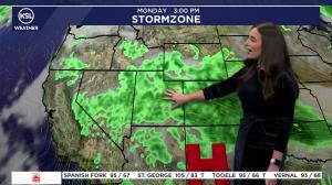
Some light mountain showers are possible on Tuesday, but the brunt of the action will begin Wednesday morning. Showers and thunderstorms are expected to pick up in southern Utah first, especially areas south of I-70.
These will continue in waves throughout the day, impacting central and eastern Utah as the day continues. A storm could make its way into the Wasatch Front by the late afternoon, but it's less likely than the regions south of it, Johnson said.
Scattered showers are possible across central and southern Utah Wednesday night into Thursday morning, likely growing in intensity.
KSL Weather models indicate that communities like Cedar City, Kanab and Hanksville could end up with at least an inch of rain by Thursday night. Communities like Blanding could see over 2 inches, while other parts of central and southern Utah, like Price, Moab and St. George, could have over 0.5 inches.
"We can't hang our hat on this, but it is giving us an indication of what's possible: 1 to 2 inches for a lot of locations," Johnson said, adding that mountaintops will likely receive higher totals as the flood watches suggest.
Storms to impact Wasatch later in week
Scattered showers are more likely to break into the Wasatch Front and northern Utah by Thursday night, as the storm is expected to split over Utah, he added. Utah's northern half will pick up the brunt of what's left to close out the workweek.
Many Wasatch Front and northern Utah communities could collect up to an inch of rain or more by early Saturday, with higher totals closer to 2 inches or more possible in the mountains, according to KSL Weather models updated on Tuesday.
That, of course, could change ahead of its arrival.
Snow levels will likely drop from approximately 11,000 feet elevation on Thursday to 8,000 feet elevation on Friday, as cooler weather arrives with the system, Johnson said. Snow totals will be more certain in the coming days, but preliminary models estimate 3-6 inches in areas above 8,500 feet elevation.
High temperatures are forecast to drop from the low 70s in the Salt Lake City area on Thursday to the mid-50s on Friday and Saturday.
While flooding risks continue this week, the plus side is it will continue to keep providing good soil moisture levels across the state.
Last week's weather, led by the remnants of Tropical Storm Rachel, elevated Utah's statewide mountain soil moisture to record-high levels for mid-October. This week's weather could push those levels to the highest in meteorological fall since records began in 2006.
Higher levels allow for potentially better snowpack runoff efficiency next spring.
Full seven-day forecasts for areas across Utah can be found at the KSL Weather Center or on the KSL Weather app.