'%3e%3cpath%20d='M34.1406%205.85938C30.3906%202.10547%2025.3047%200%2020%200C14.6953%200%209.60938%202.10547%205.85938%205.85938C2.10938%209.61328%200%2014.6953%200%2020C0%2025.3047%202.10547%2030.3906%205.85938%2034.1406C9.61328%2037.8906%2014.6953%2040%2020%2040C25.3047%2040%2030.3906%2037.8945%2034.1406%2034.1406C37.8906%2030.3906%2040%2025.3047%2040%2020C40%2014.6953%2037.8945%209.60938%2034.1406%205.85938ZM37.0117%2023.543H31.1602V13.5391H27.6328V19.9414C28.1211%2020.6914%2028.3711%2021.582%2028.3711%2022.5625V22.625C28.3711%2023.668%2028.1172%2024.6055%2027.6328%2025.4297V26.6094H36.082C33.4883%2032.9375%2027.2891%2037.3789%2020.0039%2037.3789C10.3711%2037.3789%202.62109%2029.6289%202.62109%2020C2.62109%2010.3711%2010.3711%202.62109%2020%202.62109C29.6289%202.62109%2037.3789%2010.3711%2037.3789%2020C37.3789%2021.1484%2037.2617%2022.2656%2037.0508%2023.3477C37.0391%2023.4141%2037.0234%2023.4766%2037.0117%2023.543Z'%20fill='white'/%3e%3cpath%20d='M22.3086%2018.5352C20.4336%2018.125%2019.9531%2017.8398%2019.9766%2017.1836V17.1406C19.9766%2016.6992%2020.3477%2016.2148%2021.4023%2016.2148C22.582%2016.2148%2023.8867%2016.6797%2025.0781%2017.4766L26.8516%2015.0195C25.4453%2013.8906%2023.707%2013.3398%2021.5547%2013.3398C18.5195%2013.3398%2016.4375%2015%2016.4063%2017.4766V17.5352C16.3633%2020.2617%2018.5859%2020.9805%2021.293%2021.6016C23.0391%2021.9766%2023.5703%2022.3164%2023.5703%2022.9609L23.5469%2022.9766C23.5469%2023.3906%2023.2578%2023.7031%2022.7852%2023.8359C22.5742%2023.9062%2022.1289%2023.9727%2021.5156%2023.9727C20.7617%2023.9727%2019.7539%2023.8633%2018.6328%2023.4844C18.0898%2023.2891%2017.4727%2023.0039%2016.8047%2022.6133L20.1406%2026.625C20.2813%2026.6602%2021.0977%2026.8516%2021.7734%2026.8516C25.0039%2026.8516%2027.0859%2025.2461%2027.1094%2022.6328V22.5703C27.1602%2020.1133%2025.2148%2019.1719%2022.3086%2018.5352Z'%20fill='white'/%3e%3cpath%20d='M5.24219%2013.5664V26.6133H8.75391V23.7578L10.2969%2021.9531L14.2031%2026.6133H18.3867L12.3555%2019.5195L17.4023%2013.5664H13.4531L8.75391%2019.0586V13.5664H5.24219Z'%20fill='white'/%3e%3c/g%3e%3cdefs%3e%3cclipPath%20id='clip0_97_2430'%3e%3crect%20width='40'%20height='40'%20fill='white'/%3e%3c/clipPath%3e%3c/defs%3e%3c/svg%3e)


- Mudslides closed Diamond Fork Road in Utah County due to heavy rain Friday.
- Flash flood warnings were issued in southern Utah including Zion National Park.
- Storms helped reduce fire activity and improve drought conditions across Utah.
SPANISH FORK — A popular recreation road closed because of mudslides covering it.
Diamond Fork Road is closed at Monk's Hollow farther up Diamond Fork Canyon east of Spanish Fork, the Utah County Sheriff's Office reported on Friday. County road crews are working to get the road open, authorities added.
At least one National Weather Service site in the mountains east of Utah County reported receiving over an inch of rain on Friday. It's unclear how long the road closure will last, but officials said that it may be in place for some time.
"With the amount of debris and mud on the road, it may be closed for a large portion of the weekend," the agency added.
The mudslides add to what has been another active day of weather impacts across the state.
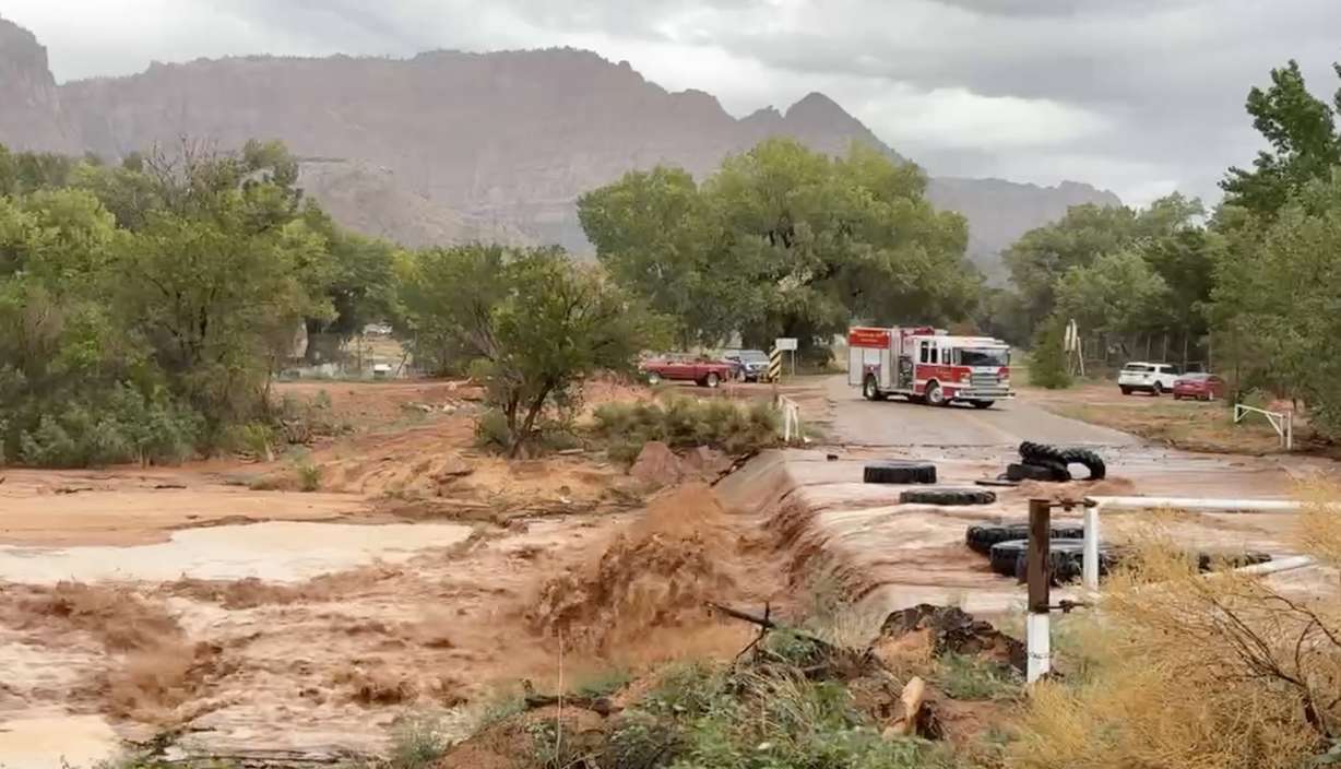
It started early, as a band of storms impacted southwest Utah in the morning. Multiple flash flood warnings were issued across the region again on Friday, including at Zion National Park, Hildale and Hurricane, some of which lasted into the afternoon.
One site near Apple Valley southeast of Hurricane received over 1.3 inches in a short period of time.
Storms began to bubble up across the Wasatch Front Friday afternoon, zeroing in on the Salt Lake City area, prompting a flood advisory at Utah's capital city that lasted for a few hours. The city officially received 0.49 inches, which, combined with Thursday's total, has helped it soar past its August normal in just two days.
As of 5 p.m., one site in the upper Avenues neighborhood reported receiving 1.55 inches during the afternoon, and a site in South Salt Lake collected 1.66 inches.
Street flooding was reported in southern Utah and in parts of the Wasatch Front. Some severe thunderstorm warnings and special weather statements have also been issued at times throughout the day across the state, although nothing as drastic as Thursday.
The weather service issued its first tornado warning in 15 years for a storm that developed in Tooele County before dissipating as it moved east. It still dumped close to 2 inches of rain in Sandy, even flooding I-15 for some time.
Additional scattered storms are anticipated across the state Friday evening while the active pattern continues to spawn storms. Storms will become even more scattered on Saturday, as a high-pressure system helping push moisture into the state continues to move away from the region, said KSL meteorologist Kevin Eubank.
Most of any storms in Utah Saturday and Sunday will remain in higher elevation areas, he added.
"We are quieting down. We are warming back up, as temperatures start their return back to normal," he said, noting that highs are forecast to top out in the low- to-mid 90s across the Wasatch Front and triple digits in St. George next week.
While the storms have brought flooding, they have helped slow down the state's fire activity again. Containment of the Widemouth 2 Fire in central Utah, the state's largest fire this year, has jumped to 65%, double what was reported two days ago.
They've also helped the state's drought conditions. At least 93% of the state remains in severe or extreme drought, the U.S. Drought Monitor reported on Thursday.
This story will be updated. To be notified about updates, please click Follow This Story below on the KSL app.