Estimated read time: 4-5 minutes
SALT LAKE CITY — Utah's newest water year opened on a very warm note, but October's stormy second half helped prevent the state from being too dry — at least in several regions, according to newly released climate data.
The National Centers for Environmental Information, which tracks statewide climate data dating back to 1895, reported Friday that last month was Utah's warmest October in at least 130 years. The average temperature of 55.9 degrees was 7 degrees above the 20th-century normal and 0.6 degrees above the previous record set in 1988.
The record wasn't too surprising, given that Salt Lake City and several other Utah cities broke temperature records last month. Box Elder, Duchesne, Iron, Tooele and Washington were the only counties that didn't break October records, but last month ended up in the top three warmest in those counties.
However, largely thanks to storms that pounded the state during the second half of October, the state got off to a solid start to the water year, which began on Oct. 1. The state collected an average of 1.15 inches of precipitation, which was just 0.08 inches off the 20th-century normal and about the middle of the pack when ranking wettest and driest months since 1895.
The Natural Resources Conservation Service reported Utah's mountain locations averaged about 2 inches of precipitation in October, 0.2 inches below its 30-year normal.
First snow
The October storms included some early snowpack. The state's average snowpack — the amount of water in mountain snow — ended up about 0.4 inches on Oct. 31, a tick above normal.
Jordan Clayton, a hydrologist for the agency, wrote that the snowpack Utah did receive was too "minimal" to consider, in a report updating Utah's water situation on Tuesday. He added it's far too early in the water year to worry about snowpack, either.
Snowpack collection generally begins around October, which is why the state's water year starts on Oct. 1. It tends to gradually pick up, especially by November and December, and typically builds until it reaches a peak in early April before it starts to melt. About 95% of the state's water supply is attributed to snowpack.
"Last winter's snowpack started slow but ended above normal," he wrote. "Many other recent years have started strong but then flatlined in January with the presence of blocking atmospheric high-pressure systems. Long story short: We welcome the snow but will wait to get too excited about it until much later in the season."
Clayton noted that the storms helped the statewide soil moisture levels end up at 35% saturation, which is below normal but about the same as at the end of October last year.
Soil moisture is considered a key stat when it comes to springtime snowpack runoff. Experts say more snowmelt goes toward recharging the state's underground water system when soil moisture is dry, but more snowmelt ends up in streams, rivers, lakes and reservoirs when soil levels are wet.
Utah's reservoir system does have a leg up on next year, though. It remains about 73% full, which is about the same as last November and 20 percentage points above average for this time of the year, per state data.
Who did and didn't benefit from storms
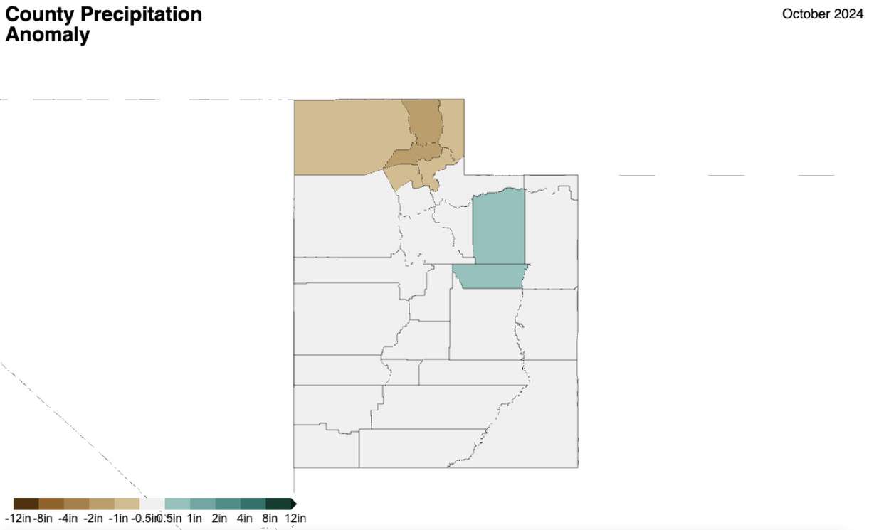
Last month's storms appear to have benefitted the Wasatch Backcountry, southern end of the Wasatch Front and parts of central and southeast Utah the most. Summit County collected the most with 2.26 inches, which made for its 56th-wettest October on record, per National Centers for Environmental Information data.

Carbon County — at 2.24 inches — ended up with the highest positive anomaly, finishing the month 0.83 inches above its October normal. It was the county's 25th-wettest October on record. Clayton noted the nearby Uinta Basin also benefited greatly from October moisture.
"Soil moisture levels in the Uinta Basin bounced dramatically from record-dry in early October to around the bottom 30th percentile following the mid-October storms," he wrote.
It was a different story for northern Utah and parts of southwest Utah, which the statewide soil moisture "glosses over," Clayton added.
The regions still received precipitation but at lower rates than normal. For example, Box Elder, Cache and Weber counties averaged about 0.94 inches combined, but last month landed in the bottom 30 all-time for all three counties in 130 years.

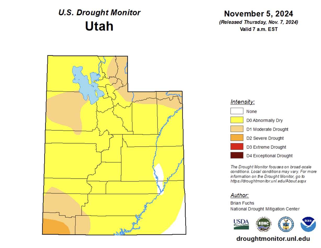
Unsurprisingly, the U.S. Drought Monitor reported that moderate drought formed within parts of the region during the month. About 97% of the state remains at least "abnormally dry," including nearly one-fifth of the state in moderate or severe drought.
A strong November start
Utah's average snowpack is now standing at nearly an inch a week into November, doubling since October ended. Recent winter storms even helped Solitude Mountain Resort and Brian Head Resort kickstart Utah's ski and snowboard season on Friday.
Near-term and long-range forecasts favor this trend to continue through at least the middle of the month. KSL meteorologist Matt Johnson said more rain and snow are likely with a cold front on pace to arrive on Tuesday.
National Weather Service Climate Prediction Center outlooks through Nov. 21 currently list Utah as having a stronger probability of above-normal precipitation, especially toward the end of the outlook. This includes a slightly higher probability of heavy snow.
Full seven-day forecasts for areas across Utah can be found online, at the KSL Weather Center.


