
Estimated read time: 5-6 minutes
- Utah has received above-normal rain since mid-July, but over 90% remains in drought.
- Severe drought decreased from 95% to 51% due to strong precipitation over past 3½ months.
- Snowpack, crucial for water supply, was below normal, affecting drought recovery.
SALT LAKE CITY — Utah's run of moisture over the past three and a half months continues to chip away at its drought.
Over 90% of the state remains in drought, but the percentage in severe or worse drought slid from 62% to 51% over the past week, the U.S. Drought Monitor reported on Thursday. Only 13.5% remains in extreme drought.
The ongoing reduction comes as Utah's mountain snowpack sites have, on average, now collected more than 12 inches of precipitation since July 15. Stormy patterns have lingered into meteorological fall, with at least 4.7 inches of that accumulating in October.
It's about 4 inches above what Utah typically receives from mid-July through October, per Natural Resources Conservation Service data.
Utah's mountain soil moisture levels have responded favorably, with mountain averages jumping from 32.2% soil saturation on July 15 (well below normal even for the summer) to as high as 71.4% last week, a record for meteorological fall.
Higher soil moisture levels can improve snowpack runoff efficiency in the spring, and snowpack accounts for 95% of the state's water supply.
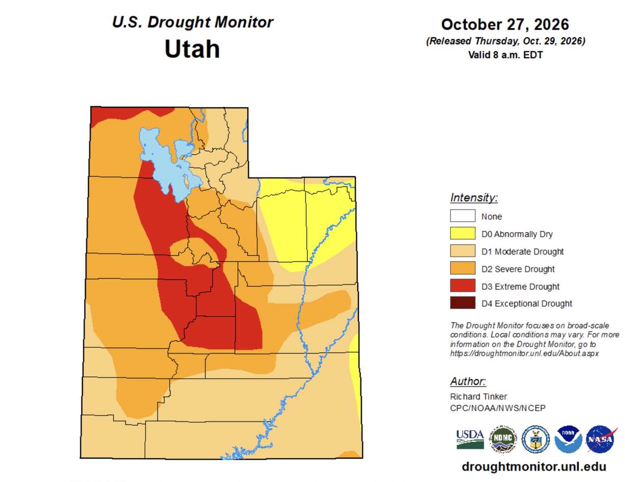
As for drought conditions, nearly 95% of the state was in severe or worse drought by mid-July, including almost 40% in extreme or exceptional drought — the worst two categories. Every section of the state remained in at least moderate drought until last week.
So why has it taken so long to chip away at drought conditions with all this rain?
The answer is both simple and incredibly complex, the authors of the U.S. Drought Monitor explained, as they pulled back their virtual curtain to explain exactly how drought is calculated.
A complicated history of drought
Drought has long been a problem in agriculture, but it has only been quantified since the Drought Monitor launched in 1999.
Lindsay Johnson, a climatologist for the National Drought Mitigation Center, pulled up a U.S. Department of Agriculture drought map from August 1934, in the middle of the Dust Bowl, to illustrate her point.
1934 stands out in Utah climate data because it produced the state's hottest and driest year on record until both of those records were broken during this decade.
The map listed the state and Intermountain West as having "ranges and dry land crops poor," while parts of the Southwest had a "very low" water supply and various other metrics were used to describe drought elsewhere.
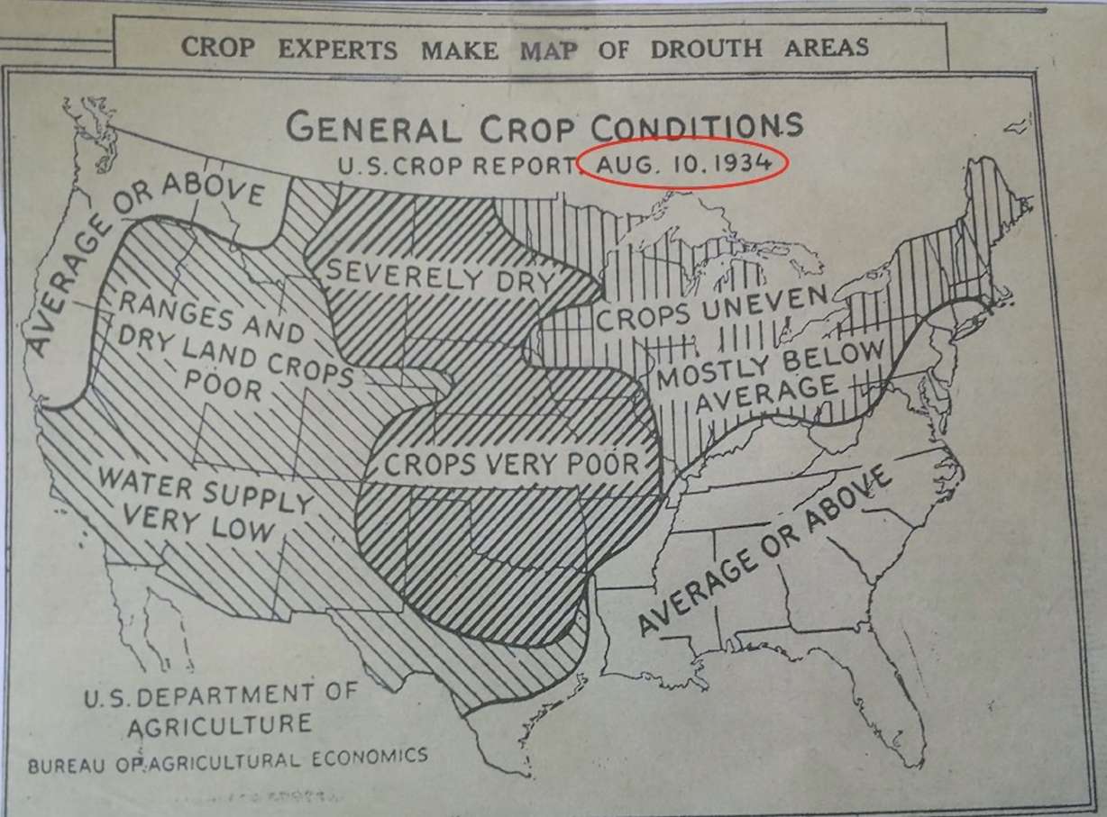
"These are all qualitative descriptions of drought, just describing ... the impacts that were occurring rather than more of a statistical, mathematical foundation," she said.
It was fairly confusing if you didn't know the region, so efforts to improve drought calculations were developed. The Palmer drought index was developed in 1965 and used more widely by the 1980s, which was an improvement, but it lacked regional context.
Then came the Drought Monitor.
A joint venture between educational and federal researchers, it takes several different weather, water, land and other observational indicators, like soil saturation or streamflows, while also taking in feedback from those in each area, to create a consensus "snapshot" of current conditions that is then compared to each area's history.
It's placed on a sliding scale based on how often those conditions should appear, using historical data. Moderate drought, for instance, is more common and should occur once every five to 10 years. Extreme and exceptional drought should happen only once every 20 to 50 years, or at most once every 100 years.
Of course, that hasn't always been the case during the West's two-decade-long "megadrought."
"You can have two 100-year floods in a matter of five years," Johnson said, and that's also true with drought.
Why is Utah still in drought?
The process is now a well-oiled machine today. Johnson is one of several rotating authors who begin every week by looking at the previous report, downloading all the latest data that goes into it and crafting a new map published every Thursday.
The short answer for why Utah remains in drought is that the data makes it clear there's no substitute for snowpack in the West. She refers to it as a "frozen reservoir" within the West's mountains.
Despite a fairly average 2026 water year in terms of precipitation, Utah's average snowpack collection was barely half of normal — its worst on record.
Although snowpack and rain are both calculations of water, rainwater "falls faster than soils can absorb it" and moves downstream faster than what Utah's water system can handle, Jon Meyer, assistant state climatologist for the Utah Climate Center at Utah State University, wrote earlier this year. This is why Utah's reservoirs barely refilled this year and have hardly improved from the past three months.
No basin in Utah and the West was spared from poor snowpack this year, so most regions entered spring and summer at a large deficit, especially when it came to soils and streamflows.
More severe drought returned this spring because of the known impacts on water supply, and it worsened as those conditions developed, said Brian Fuchs, another climatologist for the National Drought Mitigation Center.
Climbing out of drought
Large weather events can create wonky data that mimics drought recovery, though.
Utah's recent stretch has juiced soil moisture levels, as well as many creeks, streams and rivers, which has even led to flooding. Similar conditions have been reported across the West, reducing drought severity even if elements of drought persist.
The Drought Monitor includes both short-term and long-term drought to differentiate this because, yes, many of its datasets indicate an area has recovered, but it's still feeling impacts from drought, like lower reservoirs, Johnson said.
Central Utah, which still has the most extreme drought, is labeled with an "SL" on the map, meaning it has a mix of short- and long-term impacts. Other parts of the West have one or the other based on various recent patterns.
That means ongoing moisture, especially a robust snowpack this winter, is the best way Utah can climb out of drought entirely, as was the case for the last extreme drought, which ended largely because of a record-high snowpack in 2023.
Will this winter repeat 2023? It's unlikely, but then again, the same can be said about returning to extreme drought so quickly.