'%3e%3cpath%20d='M34.1406%205.85938C30.3906%202.10547%2025.3047%200%2020%200C14.6953%200%209.60938%202.10547%205.85938%205.85938C2.10938%209.61328%200%2014.6953%200%2020C0%2025.3047%202.10547%2030.3906%205.85938%2034.1406C9.61328%2037.8906%2014.6953%2040%2020%2040C25.3047%2040%2030.3906%2037.8945%2034.1406%2034.1406C37.8906%2030.3906%2040%2025.3047%2040%2020C40%2014.6953%2037.8945%209.60938%2034.1406%205.85938ZM37.0117%2023.543H31.1602V13.5391H27.6328V19.9414C28.1211%2020.6914%2028.3711%2021.582%2028.3711%2022.5625V22.625C28.3711%2023.668%2028.1172%2024.6055%2027.6328%2025.4297V26.6094H36.082C33.4883%2032.9375%2027.2891%2037.3789%2020.0039%2037.3789C10.3711%2037.3789%202.62109%2029.6289%202.62109%2020C2.62109%2010.3711%2010.3711%202.62109%2020%202.62109C29.6289%202.62109%2037.3789%2010.3711%2037.3789%2020C37.3789%2021.1484%2037.2617%2022.2656%2037.0508%2023.3477C37.0391%2023.4141%2037.0234%2023.4766%2037.0117%2023.543Z'%20fill='white'/%3e%3cpath%20d='M22.3086%2018.5352C20.4336%2018.125%2019.9531%2017.8398%2019.9766%2017.1836V17.1406C19.9766%2016.6992%2020.3477%2016.2148%2021.4023%2016.2148C22.582%2016.2148%2023.8867%2016.6797%2025.0781%2017.4766L26.8516%2015.0195C25.4453%2013.8906%2023.707%2013.3398%2021.5547%2013.3398C18.5195%2013.3398%2016.4375%2015%2016.4063%2017.4766V17.5352C16.3633%2020.2617%2018.5859%2020.9805%2021.293%2021.6016C23.0391%2021.9766%2023.5703%2022.3164%2023.5703%2022.9609L23.5469%2022.9766C23.5469%2023.3906%2023.2578%2023.7031%2022.7852%2023.8359C22.5742%2023.9062%2022.1289%2023.9727%2021.5156%2023.9727C20.7617%2023.9727%2019.7539%2023.8633%2018.6328%2023.4844C18.0898%2023.2891%2017.4727%2023.0039%2016.8047%2022.6133L20.1406%2026.625C20.2813%2026.6602%2021.0977%2026.8516%2021.7734%2026.8516C25.0039%2026.8516%2027.0859%2025.2461%2027.1094%2022.6328V22.5703C27.1602%2020.1133%2025.2148%2019.1719%2022.3086%2018.5352Z'%20fill='white'/%3e%3cpath%20d='M5.24219%2013.5664V26.6133H8.75391V23.7578L10.2969%2021.9531L14.2031%2026.6133H18.3867L12.3555%2019.5195L17.4023%2013.5664H13.4531L8.75391%2019.0586V13.5664H5.24219Z'%20fill='white'/%3e%3c/g%3e%3cdefs%3e%3cclipPath%20id='clip0_97_2430'%3e%3crect%20width='40'%20height='40'%20fill='white'/%3e%3c/clipPath%3e%3c/defs%3e%3c/svg%3e)


- Utah's wildfires have burned over 505,000 acres, eclipsing the 500,000-acre mark for only second time ever.
- Monsoonal moisture may help reduce fire activity, following recent bout of dry conditions.
- Rains can also improve soil moisture levels, but also increase risk of flooding.
SALT LAKE CITY — Utah's wildfires reached an undesired feat only seen once before in modern history, but there's hope that another round of monsoons can help quell the state's fire danger.
More than 505,000 acres have now burned across Utah this year, marking just the second time the state's fires have burned at least 500,000 acres since record-keeping began. The only other time that has happened was 2007, which still holds the record of 629,212 acres, according to the Utah Division of Forestry, Fire and State Lands.
Utah's recent acreage surge is mostly tied to the massive growth of the Widemouth 2 Fire, which has now surpassed the Babylon Fire as Utah's largest fire this year. It has now burned at least 111,000 acres after starting in Millard County last month, U.S. Forest Service officials said on Saturday.
Despite its growth, firefighters were able to gain more control of the fire, increasing containment from 10% on Thursday to 24% on Friday.
However, they cautioned that some parts of the fire, including a section nearing I-70, are extremely active. A few other smaller fires have popped up over the past week, adding to the surge as hot and dry conditions have helped spread fires.
Nearly a quarter of the state's acreage burned this year has come within the past 10 days, after the first round of monsoon moisture ended.
"Everything that is available to catch fire is catching fire. It's very explosive," said Tony DeMasters, incident commender for Great Basin Team 2, which is currently overseeing the massive Widemouth 2 Fire, on Thursday.
Approximately 28,700 firefighting personnel are currently assigned to fires raging across the U.S., limiting the number of resources that are available for current or new starts. The Great Basin region jumped to preparedness Level 5, the highest level, on Thursday because of the renewed threat of fires mixing in with the number of resources committed to other fires.
Monsoonal return
However, weather models suggest monsoonal moisture will soon return to Utah, which may help slow down activity.
A strong high-pressure system remained over Utah on Friday, helping keep conditions hot and dry, prompting the National Weather Service to issue more extreme heat warnings, heat advisories and red flag warnings tied to heat and fire danger.
Those will linger toward the first half of the weekend, but the high-pressure system is forecast to zig-zag around the Four Corners region beginning at the end of it and the start of next week, opening the door for oceanic moisture to flow back into Utah, said KSL meteorologist Devan Masciulli.
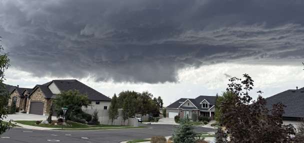
The threats of microbursts and dry lightning are possible this weekend, she cautions, but the probability of rain-producing storms and thunderstorms developing will increase during the workweek as the high-pressure system moves east.
Most of this will likely stick to mountain areas first, with models hinting that there might not be enough upper-level steering winds to push storms into the valleys.
"Each day, this will still promote moisture in the atmosphere to keep daily thunderstorm chances," she said.
Weather models, she added, indicate some low-pressure systems will try to form near the Pacific Ocean toward the middle- to-late end of next week, pushing the high-pressure system further east. That could help promote more widespread rain probabilities that could develop in valley communities, especially in southern and central Utah.
It's unclear how far north these will go. Some models hint that the storms may only reach parts of the Wasatch Front. That's something that will likely become clearer in the coming days, as models gain more certainty.
It's also unclear how long the pattern will last or how much it will produce.
"Wonky" signals are showing up in some models, suggesting storms remaining in the forecast through at least Friday, but drier conditions could return next weekend, Masciulli said. Yet, many long-range models still list Utah as having above-normal precipitation probabilities through the middle and end of the month, indicating that any slowdown might be short-lived.
Precipitation amounts are notoriously difficult to predict, depending heavily on where storms form and how much rain is produced when they form. Panguitch Lake received more than 7 inches of rain from monsoonal storms last month, while the Uinta Basin struggled to receive moisture from the last wave of monsoons, which ended toward the end of July.
Utah's statewide mountain and valley moisture levels ended the month at above-normal, with some regions faring better than others, federal hydrologists noted. Higher soil moisture levels can help reduce evaporative loss and fire risk, and improve snowpack efficiency during the following spring.
That's the upside, but storms can also produce flash flooding at new or recent fire burn scars, which was also the case last month. Communities close to the Widemouth 2 Fire said on Thursday they are now preparing for that threat, given the forecast.
"Mother Nature doesn't care about our time frames. We can be fighting a fire one minute and then fighting a flood the next minute," Gov. Spencer Cox said. "We have to be able to walk and chew gum at the same time."
Full seven-day forecasts for areas across Utah can be found online at the KSL Weather Center.