- A new map identifies nearly 60,000 structures at high wildfire risk in Utah.
- The map, effective 2026, introduces fees for high-risk properties to fund prevention.
- Fees range in cost, but can be reduced by actions to lower fire risk, officials said.
SALT LAKE CITY — Close to 60,000 structures across Utah are considered at "high risk" for being impacted by wildfires, putting some homeowners on the path to pay new fees, according to a new state map outlining which areas are most prone to destructive wildfires.
The Utah Division of Forestry, Fire and State Lands unveiled its first-ever High-Risk Wildland Urban Interface map on Thursday, identifying properties at the highest risk of damage from fires. It's available for everyone to review to see if they're included, while it will also be downloadable for homeowners, insurance companies, researchers or anyone else who needs it, division officials said.
"(It seeks to) address the impacts of wildfire in Utah within the wildland urban interface," said Joseph Anderson, wildlife risk reduction manager for the division.
The map, which goes into effect at the start of 2026, was required under HB48, a bill that Utah lawmakers passed earlier this year, seeking to address property risks within places where homes and urban spaces mix with wild spaces.
It cleared the Utah Legislature amid the growing concerns about destructive wildfires in Utah and across the West, which became even more pressing following the devastating wildfires in Los Angeles at the start of the year.
The new law introduced fees for property owners at the highest risk, which goes into a fire prevention and mitigation fund that pays for lot assessments and other tools to help reduce the risk of fires reaching homes. These fees will likely range between $20 and $100 per structure, but can be reduced with assessments that show that the owner has taken steps to reduce fire risk, state land managers explained.
It also instructed insurance companies to utilize the boundaries when identifying high-risk properties. While land managers say this data likely isn't new to them, this allows for more uniformity across different providers.
Alex Cabrero, KSLFinding Utah's riskiest areas
But determining who is at the highest risk — the top 5% of danger — took months of data reviews and insight from experts, which were refined from various sources during multiple steps, Anderson said.
The team started by pulling in satellite-collected vegetation data to outline where different fire "fuels" are located throughout the state. This was then refined to exclude areas such as agricultural lands and city parks that aren't necessarily wildland.
Fire and weather data were then plugged into the system, helping the team create a simulation to determine where fires are most likely to occur within wildland areas and how they'd burn based on different vegetation types.
A few other variables were also considered before the team shifted its focus to buildings, Anderson said. The team explored buildings that are within closer proximity of each other to determine the wildland urban interface. The two datasets were merged into a map that outlines threat level from 1 to 8, with those at 7 or 8 having the highest risk.
Where is the risk?
Close to 60,000 structures fall under the highest two risk categories and are located within 820 feet of two or more other structures in the first version of the map, ending up in the high-risk wildland urban interface area.
These buildings are located all over the state for different reasons.
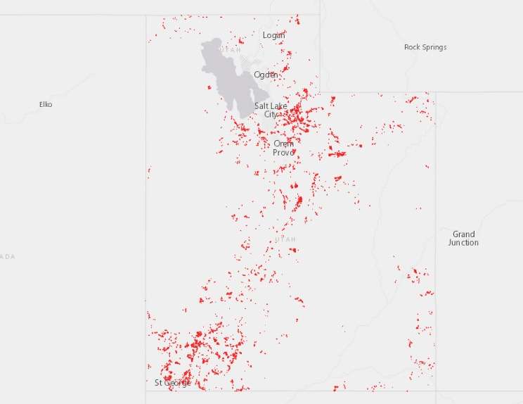
Many parts of southern Utah are included because of the probability of fire, while northern Utah risks are based on their proximity to a mixed-conifer forest with greater damage potential, said Taiga Rohrer, deputy state fire management officer for the Utah Division of Forestry, Fire and State Lands.
"You have a higher probability of fire with grass or brush in a high desert than you do up at 9,000-10,000 feet (elevation), but the fire behavior is quite different," he explained. "That plays into what is 'high risk.'"
What happens next?
Counties collect the fees that will pay for the lot assessments program. Costs will range based on "triage scores," which are essentially the steps high-risk property owners have taken to create defensible spaces or other tactics to lower the risk of fire damage, Rohrer said.
Rates may change a few years into the program as it gets going, but he said having assessments and taking steps to reduce the risk of wildfire-related damage could help homeowners in prone areas retain insurance, which is important because that's been a concern amid the growth of wildfires in the West.
Triage scores can be provided to insurers to show what property owners have done to reduce risks.
"That triage score relays quite a bit of information (about) what that property owner has done," Rohrer said. "If they've lowered their triage scores to the lowest they can get, then they've done all the work necessary of what they can do to reduce the risk. It won't eliminate the risk, but it does reduce the risk."
Property assessments would last five years, as dangerous fire conditions can return without regular care. However, the state also plans to adjust its maps regularly to meet changes in Utah's growth, wildfire patterns and other factors that can raise or lower at-risk properties.
State land managers are already planning to meet with cities, counties and others to better refine the first map, Anderson said.
"Our work is just beginning," he said. "We'll be updating this on an annual basis."