Estimated read time: 4-5 minutes
This archived news story is available only for your personal, non-commercial use. Information in the story may be outdated or superseded by additional information. Reading or replaying the story in its archived form does not constitute a republication of the story.
SALT LAKE CITY — Utah was on pace to post one of its hottest and driest meteorological summers on record, but that may no longer be the case now monsoonal storms have left a mark.
The Beehive State entered August on pace for its second-hottest and 19th-driest summer since at least 1895, per National Centers for Environmental Information data.
- Utah's average temperature for the last two months reached 73 degrees, more than 5 degrees over the 20th-century average; 1.1 degrees behind the two-month record set in 2021.
- Its 0.95 inches of rain collected throughout June and July was 0.77 inches below average and the worst since 2018.
However, August may help Utah drop down the list in both dubious categories. Monsoonal moisture has helped cities across the state snap dry spells and avoid excessive heat.
Salt Lake City, for example, has already received 1.15 inches of rain this month, nearly triple what it got in June and July, combined. It also snapped a 38-day streak of high temperatures reaching at least 90 degrees.
This mirrors what has happened in other Utah cities and towns, including ones that have received much more rain than the state capital this month.
"Some areas have already reached their summer (precipitation) average ... just with this last monsoon surge," said KSL meteorologist Matt Johnson. "Many have made up what was lost."
There's now growing optimism that storms can linger into the next meteorological season, even if the National Weather Service Climate Prediction Center lists most of Utah as having a larger probability for above-normal temperatures and below-normal temperatures than other parts of the country.
Utah's fall outlook
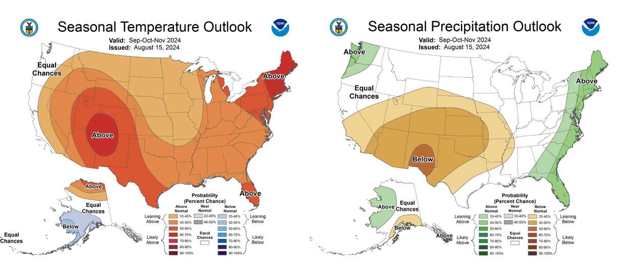
Most of Utah is listed as having a 33% to 40% probability of below-normal precipitation throughout the meteorological fall months of September, October and November, according to the climate center's seasonal outlook released Thursday.
There's a slightly greater probability of below-average precipitation in southeastern Utah, while a sliver of northwest Utah is listed as having "equal chances" — no clear signal whether above, below or near-normal precipitation conditions will exist.
Most of Utah has a 50% to 60% probability of above-normal temperatures, as well. The Four Corners region, including southeastern Utah, has a 60% to 70% probability of above-normal temperatures over the three months. The outlook is based on current and historic atmospheric and oceanic conditions.

While it leans toward Utah having hotter and drier conditions than normal, it's better than previous three-month outlooks that reached as far out as October. Those listed most of Utah as having 40-50% of below-average precipitation, which was the highest probability of anywhere in the country.
The highest probability for drier conditions has now shifted to the New Mexico-Texas border. The update also introduces probabilities leaning toward above-normal precipitation in the Pacific Northwest while most of the West is listed as having equal chances.
These changes likely indicate that forecasters believe a consistent high-pressure system — one that would block storms from coming into a certain area — will set up somewhere over the West throughout the season, Johnson said. Previous models suggested it could be over Utah, while the new one suggests it may end up over eastern New Mexico or possibly the Four Corners region.
Where it lands will dictate Utah's fall precipitation totals. The farther southeast it sets up from Utah, the more likely it will be that fall storms pass through the state rather than bounce around it.
"For as much as the outlook is saying drier-than-normal for Utah, we're going to sit on that line," he said. "I wouldn't be surprised if we actually meet our averages for fall simply because if that high-pressure system sets over New Mexico, that means we're on the western (edge) and so that storm door is not completely closed. ... It looks like a generic setup for fall."
Why fall matters
A normal fall would be beneficial for the state's water supply, which is dependent almost entirely on snowpack.
Utah water managers said last week they'd like to see more monsoon moisture to improve dry soil moisture levels, which factor into the efficiency of snowpack runoff in the spring. The wetter the soil moisture the more snowpack runoff will end up in lakes and reservoirs than recharging a depleted underground water system.
Meteorological fall is equally important. The traditional cold front storm patterns produce a greater chance of precipitation throughout a wider region typically return during the fall months.
It's why — based on the 30-year normal — the state's average statewide precipitation jumps from 2.65 inches during the summer to 3.47 inches during fall. Fall is technically the state's third-driest season overall but the difference between fall and spring — the state's wettest season — is just 0.30 inches.
Snowpack collection also tends to begin during the season, which is why every Utah water year starts on Oct. 1.
Meteorologists, hydrologists and water managers will all be watching closely to see where the high-pressure system sets up this fall to see if Utah can continue to receive much-needed rain. They'll also track the La Niña oceanic pattern expected to arrive during meteorological winter.
"That's why fall is key," Johnson said. "It's not the end of the world if we can't get (fall storms), but an ideal setup is to get these storms going, get the soil moisture elevated and saturated and then drop your snow."


