'%3e%3cpath%20d='M34.1406%205.85938C30.3906%202.10547%2025.3047%200%2020%200C14.6953%200%209.60938%202.10547%205.85938%205.85938C2.10938%209.61328%200%2014.6953%200%2020C0%2025.3047%202.10547%2030.3906%205.85938%2034.1406C9.61328%2037.8906%2014.6953%2040%2020%2040C25.3047%2040%2030.3906%2037.8945%2034.1406%2034.1406C37.8906%2030.3906%2040%2025.3047%2040%2020C40%2014.6953%2037.8945%209.60938%2034.1406%205.85938ZM37.0117%2023.543H31.1602V13.5391H27.6328V19.9414C28.1211%2020.6914%2028.3711%2021.582%2028.3711%2022.5625V22.625C28.3711%2023.668%2028.1172%2024.6055%2027.6328%2025.4297V26.6094H36.082C33.4883%2032.9375%2027.2891%2037.3789%2020.0039%2037.3789C10.3711%2037.3789%202.62109%2029.6289%202.62109%2020C2.62109%2010.3711%2010.3711%202.62109%2020%202.62109C29.6289%202.62109%2037.3789%2010.3711%2037.3789%2020C37.3789%2021.1484%2037.2617%2022.2656%2037.0508%2023.3477C37.0391%2023.4141%2037.0234%2023.4766%2037.0117%2023.543Z'%20fill='white'/%3e%3cpath%20d='M22.3086%2018.5352C20.4336%2018.125%2019.9531%2017.8398%2019.9766%2017.1836V17.1406C19.9766%2016.6992%2020.3477%2016.2148%2021.4023%2016.2148C22.582%2016.2148%2023.8867%2016.6797%2025.0781%2017.4766L26.8516%2015.0195C25.4453%2013.8906%2023.707%2013.3398%2021.5547%2013.3398C18.5195%2013.3398%2016.4375%2015%2016.4063%2017.4766V17.5352C16.3633%2020.2617%2018.5859%2020.9805%2021.293%2021.6016C23.0391%2021.9766%2023.5703%2022.3164%2023.5703%2022.9609L23.5469%2022.9766C23.5469%2023.3906%2023.2578%2023.7031%2022.7852%2023.8359C22.5742%2023.9062%2022.1289%2023.9727%2021.5156%2023.9727C20.7617%2023.9727%2019.7539%2023.8633%2018.6328%2023.4844C18.0898%2023.2891%2017.4727%2023.0039%2016.8047%2022.6133L20.1406%2026.625C20.2813%2026.6602%2021.0977%2026.8516%2021.7734%2026.8516C25.0039%2026.8516%2027.0859%2025.2461%2027.1094%2022.6328V22.5703C27.1602%2020.1133%2025.2148%2019.1719%2022.3086%2018.5352Z'%20fill='white'/%3e%3cpath%20d='M5.24219%2013.5664V26.6133H8.75391V23.7578L10.2969%2021.9531L14.2031%2026.6133H18.3867L12.3555%2019.5195L17.4023%2013.5664H13.4531L8.75391%2019.0586V13.5664H5.24219Z'%20fill='white'/%3e%3c/g%3e%3cdefs%3e%3cclipPath%20id='clip0_97_2430'%3e%3crect%20width='40'%20height='40'%20fill='white'/%3e%3c/clipPath%3e%3c/defs%3e%3c/svg%3e)


Estimated read time: 5-6 minutes
- Utah's summers have always been hot but gotten hotter in recent decades, federal climate data shows.
- Urban heat islands and early snowpack melt contribute to increasing temperature trends, experts say.
- More extreme heat is in Utah's forecast for this weekend.
SALT LAKE CITY — Extreme heat is expected across most of Utah again this weekend, as triple-digit temperatures are forecast for much of the state.
It's an all-too-familiar sight this summer, which has already smashed records. Salt Lake City broke or tied a pair of all-time temperature records already this month, setting a new highest daily maximum temperature of 109 degrees on July 13, and matching its highest daily minimum temperature of 82 degrees on Monday.
Many other cities have set new daily records over the past few weeks. It's sparked some humorous discussions on social media, including a Reddit thread where people likened Salt Lake City's recent heat to something in St. George or Arizona.
Other debates have essentially asked, have its summers always been this hot?
The answer to that is both yes and no.
There have been extreme-heat-level temperatures and notably warm seasons well before this decade, but, generally speaking, both Salt Lake City's and Utah's summers have been getting hotter, especially since the start of the 21st century, said Jon Meyer, assistant state climatologist at the Utah Climate Center at Utah State University.
"Triple digits have always been a part of Utah summers, north or southeast or west, but what has changed over the few recent decades ... is the extent of the season where we have the opportunities to have those 100s present or 95s," he told KSL.
Utah's summers over the past century
KSL combed through average temperatures and average high temperatures throughout meteorological summer (June 1 through Aug. 31) over the past century. Data compiled at the National Weather Service's Salt Lake City office and the National Centers for Environmental Information were used for this analysis, offering glimpses into the changes within Utah's capital city and the state as a whole.
Both of these show that the 2020s are off to a hotter start than anything that's been seen over at least the past century.
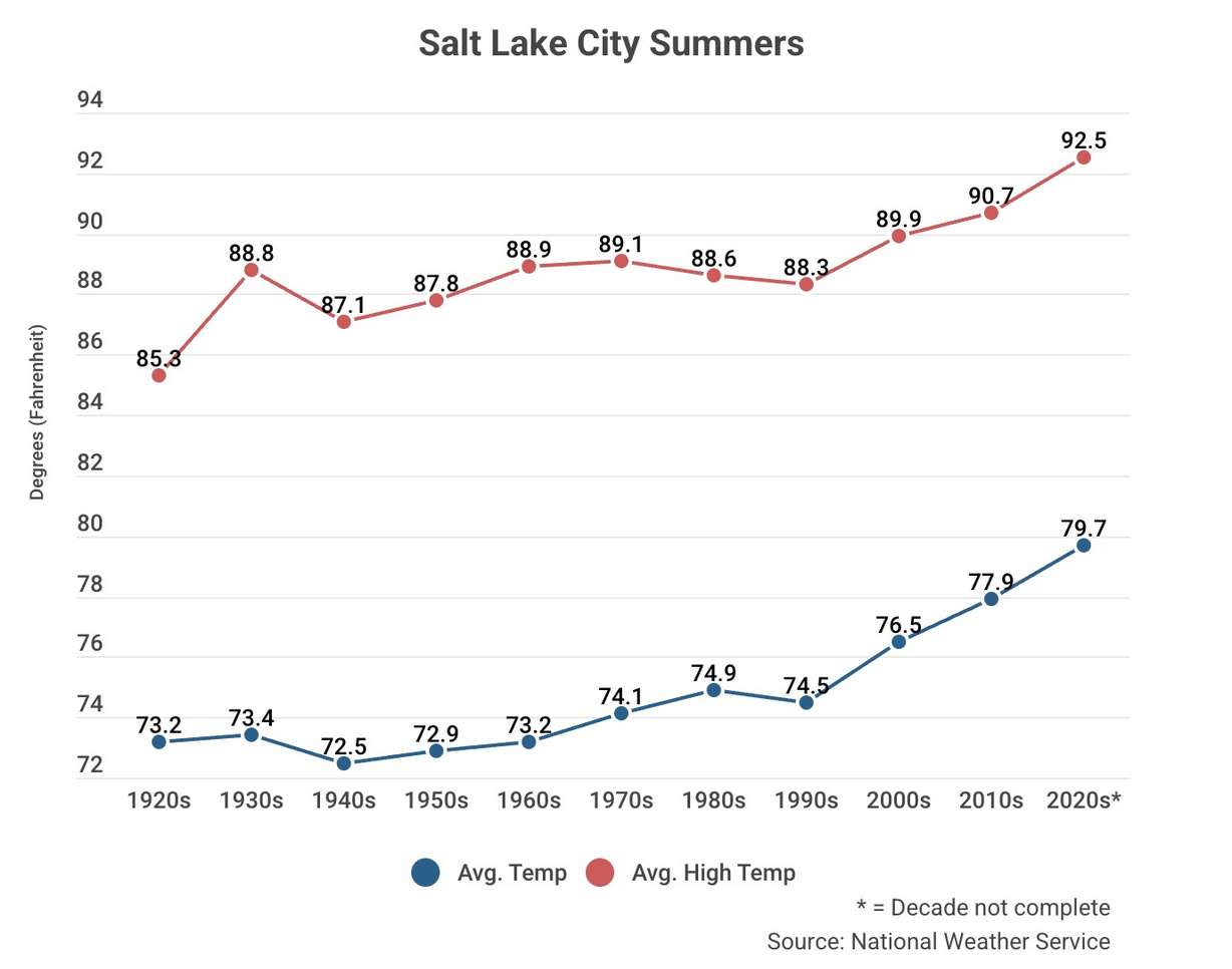
Salt Lake City's average summer high temperature between 2020 and 2025 was 92.5 degrees, up 1.8 degrees from the 2010s but 7.2 degrees from the 1920s. Its average summer temperature — a mix of the hottest and coldest points of every day throughout the season — entered this year at 79.7 degrees, nearly 2 degrees above any previous decade of the past century.
Some have argued that this is because readings are captured at Salt Lake City's airport, picking up the urban heat island effect from its concrete and asphalt. The National Weather Service defended its readings in 2022, debating, among other things, that it's representative of changes around the city and valley over the past century.
Research has long pointed to asphalt, concrete and other development holding more daytime heat longer than a natural landscape as a contributing factor in rising minimum temperatures, which factors in rising average temperatures, said Sam Webber, a meteorologist for the National Weather Service.
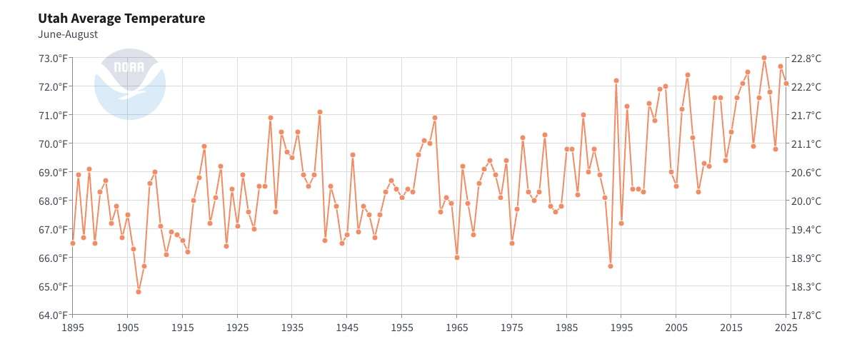
The city's increases are a piece of a similar statewide trend. Nine of the state's 10 warmest summers have come since 2000, which also aligns with approximately the start of the West's two-decade-long "megadrought."
It's not a coincidence, Meyer said. He explains that since the 2000s, Utah has experienced more years where its snowpack melts early, causing its soils to dry earlier. This allows for more of the sun's energy to heat up the land instead of evaporating soil moisture.
Higher decadal averages emerge when it becomes a more frequent pattern. It's also likely why this year has continued that trend, as Utah entered this summer coming off its worst snowpack on record.
"(Snowpack and soil moisture) kind of (act) like the brakes of our summer heat," he said. "Right now, we don't have a lot of brakes left because we're drying out and losing our snowpack so much earlier in the year that the warm season just has a much longer period of time to accumulate that energy."
But none of this is entirely linear. Utah's temperature and precipitation averages, which make up normals, are the middle point of wide extremes.
In fact, Salt Lake City's 1930s summers were, on average, warmer than either the 1940s or 1950s, and about as warm as the 1960s. Its average high temperatures in the '90s were cooler than in the '80s. When Salt Lake City set an all-time hottest temperature on record earlier this month, it broke a record that was first set in 1960.
A little over one-third of its daily records within the meteorological summer months are from before the 21st century, scattered across numerous decades.
Utah's trends are similar, even though its average summer temperatures during the 1930s were warmer than every other decade until this century. Some year-over-year trends are just odd, such as when Utah posted its second-coolest and fifth-warmest summers during consecutive years in 1993 and 1994.
These kinds of fluctuations are usually based on differing weather patterns that set up annually. Meyer agrees that the variation and some recency bias might factor into arguments comparing this summer to others in Salt Lake City's and Utah's histories.
Other considerations
This analysis doesn't capture how summer-like temperatures have also crept into other meteorological seasons in recent years. For instance, Utah recorded June-like temperatures in March, while Salt Lake City posted just one 100-degree day in September before 2019. Since then, it has recorded nine more — seven of those in 2022.
That's a trend that began toward the end of the 20th century, which has led to warmer overall years, Meyer adds.
It's also a trend that has no sign of ending anytime soon. Average temperatures within the Great Salt Lake basin are projected to increase by about 2.5-10 degrees over the rest of the decade, depending on greenhouse gas emissions, the Great Salt Lake Strike Team reported earlier this year.
That could result in hotter summers, depending on the weather setup each year. Its report also noted less change in moisture trends, which could help moderate temperatures during certain years. It's fairly representative of what the rest of the state could face.
"There's always going to be natural variability," Meyer said. "We have to keep an eye on the natural swings from year to year."