Estimated read time: 4-5 minutes
- Firefighters in Utah face challenging weather conditions this weekend with critical fire risks.
- The Cottonwood Fire has burned 72,000 acres; red flag warnings cover much of Utah.
- Monsoon season could bring relief in July, with odds favoring above-normal precipitation in the state.
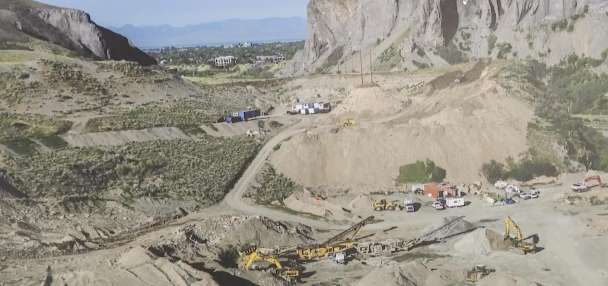
BEAVER — A fast-moving fire burning east of Beaver saw much slower growth after storms pushed across the fire on Thursday, but Jason Straub fears that this weekend will challenge firefighting efforts again.
The Cottonwood Fire has now burned close to 72,000 acres, federal firefighters said Friday morning, burning only about 2,000 acres over 24 hours. However, in a rare move, the National Weather Service issued a particularly dangerous situation for the southwestern desert, central and southern mountains, specifically calling out the Cottonwood Fire as a major concern.
"We are looking at a full 48 hours of critical weather that we have not seen in Utah in the last five years," said Straub, incident meteorologist assigned to the Cottonwood Fire, as he addressed Beaver residents in a packed auditorium Thursday night. "I hate to be the bearer of bad news, but ... (these are) serious conditions coming."
It's not just the Cottonwood Fire that's at risk this weekend, though.
The weather service issued a series of red flag warnings that blanket nearly every area in the state outside parts of the Uinta Mountains, which lasts through Sunday night in some cases. A dangerous mix of warm temperatures, strong winds and low relative humidity is expected to create "critical fire weather conditions," which can spread existing fires and spark new ones.
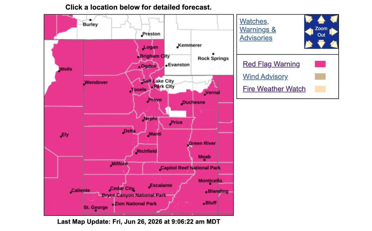
Red flag warnings were issued for most of Arizona and Nevada, along with large swaths of Colorado and New Mexico, as well as parts of California, Idaho and Oregon on Friday, as a strong low-pressure system in the Pacific Northwest moves east toward Utah.
It's helping push winds from the southwest toward Utah, bringing in hot and dry air from the Mojave Desert, said KSL meteorologist Matt Johnson. The strongest gusts in Utah are likely on Friday and Saturday as the system moves through.
"If it's cranking enough, it's not going to be a good recipe for fires," he said. "We'll be down to single-digit humidity with very strong winds and extreme fire danger in the southwest corner."
The system is creating all sorts of additional chaos in the Intermountain West. Although it's late June, a mix of winter weather advisories and winter storm watches has been issued for northeast Idaho and western Montana, which could receive several inches of mountain snow from the system.
Scattered showers and thunderstorms are likely across northern Utah and possibly across the Wasatch Front this weekend, with high temperatures forecast to dip below 70 degrees by Sunday.
A wet July ahead?
While this weekend might create more difficult fire conditions, there are signs of hope on the horizon. This week's storms brought monsoon-like conditions, delivering strong totals in some parts of the state.
Over an inch of rain fell over parts of the Salt Lake Valley from a storm on Thursday. Scattered storms also brought as much as a half-inch of rain on parts of the Cottonwood Fire, Straub said. That's after a little bit of rain on Wednesday, too.
All of it may open the door for the monsoon season, which could pick up soon.
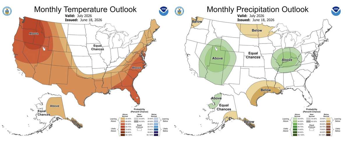
Long-range forecasts seem to favor Utah's odds next month. Nearly the entire state has a 40% to 50% probability of receiving above-normal precipitation in July, which is among the highest probabilities in the nation, according to the National Weather Service's Climate Prediction Center.
Normal ranges from location to location. July is normally one of Salt Lake City's driest months, receiving about 0.49 inches of precipitation. But some parts of the state, particularly in southern Utah, typically receive more than an inch in July due to the summer monsoon.
It also might take some time to come to fruition. The agency projects the first week of July could remain dry, before rain could pick up toward July 9. Other models also hint at this, Johnson said.
But it would help, as nearly 95% of the state remains in at least severe drought, including nearly 40% in extreme or exceptional drought.
State leaders hope the forecast will deliver, as Utah will continue to have above-normal fire risk to begin July.
"We're hoping that these monsoons are coming in. It looks like it's forecasted to be a better July," said Gov. Spencer Cox on Thursday, as he announced new fireworks restrictions for the Fourth of July. "If we have a wet July, if we have monsoons come in, the (fireworks) order goes away."