- A 7.8 magnitude earthquake hit the southern Philippines, killing at least 32 people.
- The quake caused a 3-foot tsunami and severe building damage in General Santos.
- International support was offered as rescue efforts continue amid aftershocks and missing persons.
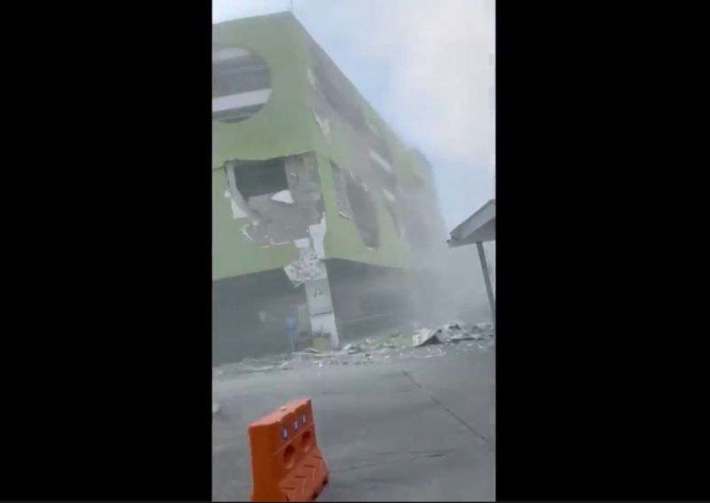
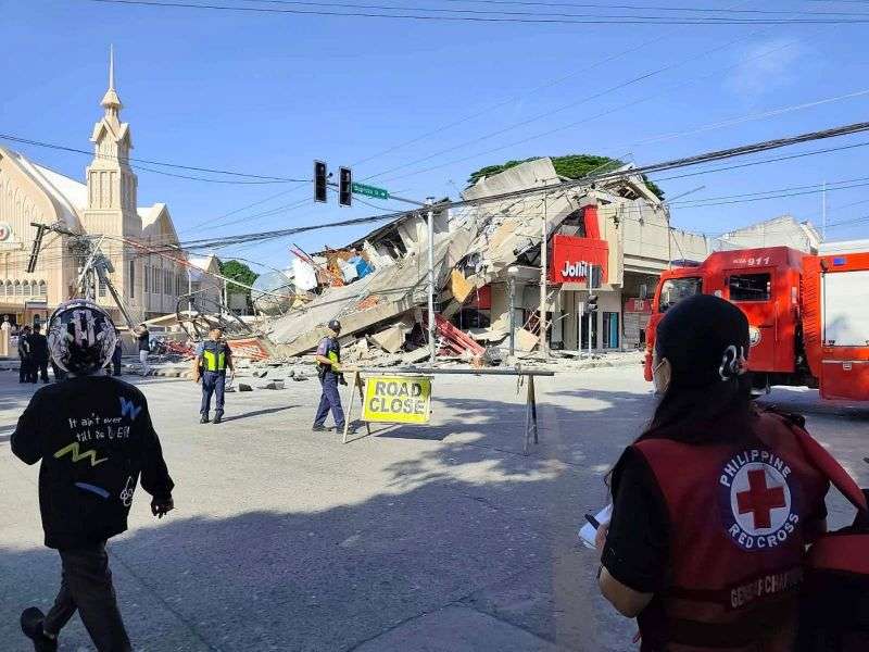
DAVAO, Philippines — An offshore magnitude 7.8 earthquake rocked the southern Philippines on Monday, killing at least 32 people, injuring more than 200 others mostly in ruined buildings and sending a 3-foot tsunami into nearby coasts.
Several mostly low-slung buildings collapsed or sustained heavy damage in the hard-hit city of General Santos. Tsunami damage was reported in at least one southern coastal village. Smaller waves were measured in Indonesia and Palau and as far away as southern Japan.
The quake also triggered a landslide in Glan, Sarangani province, that killed 13 villagers, Rene Punzalan, a provincial disaster-mitigation official, told the DZBB radio network. Four other villagers died in Sarangani, he said.
The major earthquake was the strongest to hit the Philippines this year, Teresito Bacolcol, the director of the Philippine Institute of Volcanology and Seismology, said. He warned people to seek advice before returning to damaged buildings and houses, which could collapse due to aftershocks.
The United States, a treaty ally of the Philippines, said it was coordinating with Manila and was ready to support Philippine response efforts. France and New Zealand also expressed support.
"Our pickup truck suddenly jerked, and I thought we had a flat tire," Rod Sosmeña, a regional director of the Office of Civil Defense, told the Associated Press from General Santos, where he was traveling when the quake struck at 7:37 a.m.
"The shaking was very strong, and people dashed out of houses into the streets," Sosmeña said.
More than 100 students in uniforms and a dozen teachers had gathered for a flag-raising ceremony in a coconut tree-ringed grade school compound in the rural town of Malita in Davao Occidental province when the ground shook, turning the first day of school after a two-month summer break into chaos.
"Their excitement on the first day of school turned to trauma," school principal Rosavel Cachuela told the AP.

Some of the young students screamed in panic and wept, but mostly remained seated and still, preventing any injuries, Cachuela said, adding that a motorcycle was damaged when a shed crumbled to the ground.
At least 12 people remained missing in General Santos, a port city of more than 700,000 people and a regional hub for the tuna export industry. Search and rescue teams scrambled to find people who may have been trapped in a supermarket, a warehouse, a grade school, and other small buildings that either collapsed or were severely damaged, officials said.
The international airport in General Santos was temporarily shut due to the earthquake and 17 domestic flights were canceled, the Civil Aviation Authority of the Philippines said.
The quake was centered at sea off Mindanao, the second most populous island in the Philippine archipelago. According to Bacolcol, the quake occurred at a depth of 20 miles, and about 20 miles southwest of Maasim town in Sarangani province.
Philippine President Ferdinand Marcos Jr. ordered the cancellation of classes and directed disaster-response agencies to immediately get to work in quake-hit provinces, saying "the national government is moving and we will not leave Mindanao behind."
The Pacific Tsunami Warning Center said the threat of a tsunami largely passed about five hours after the quake. Philippine officials also lifted a tsunami warning by mid-afternoon. Six shanties on stilts were damaged in a coastal village in Zamboanga del Sur province due to the quake and taller waves, officials said.
Aside from the landslide in Sarangani, most of the other deaths were caused by collapsing buildings and falling debris, including in a damaged mosque, in the southern provinces of South Cotabato and Davao Occidental, and on Balut Island, according to Sosmeña and another disaster-mitigation official, Ednar Dayanghirang.
The DZRH radio network in Manila reported that a four-story commercial building, where its provincial station was located, partly collapsed and staffers dashed to the ground floor without injuries.
Waves of 3 feet were monitored in the provinces of Sultan Kudarat and Sarangani. A 4.6-foot wave hit at one time in Kiamba town, Bacolcol said.
The quake was also felt in Malaysia's Sabah state on Borneo island. Sabah is just a boat ride away from the southern Philippines. A 2.7-foot tsunami was measured by a gauge off Indonesia's Sulawesi island, and the PTWC said 1-foot waves were measured in Palau.
Waves up to 7.8 inches were detected on the remote Japanese island of Chichijima and the central Japanese town of Kushimoto, the Japan Meteorological Agency said.
The Philippines, one of the world's most disaster-prone countries, is often hit by earthquakes and volcanic eruptions due to its location on the Pacific "Ring of Fire," an arc of seismic faults around the ocean.
The archipelago is also lashed by about 20 typhoons and tropical storms each year.
Contributing: Edna Tariga, Indonesia, Eileen Ng, Mari Yamaguchi and Kiko Rosario