Estimated read time: 4-5 minutes
- Severe storms cause two deaths and massive outages across the central U.S.
- Tornadoes, hail, and winds damage homes and infrastructure in multiple states.
- Residents urged to stay alert as storms move east, affecting millions.
KALAMAZOO, Mich. — A line of dangerous storms is sweeping east after touching off several tornadoes, dropping golf ball-sized hail and causing at least two deaths in the central U.S. this weekend.
A semitruck driver was killed in Valparaiso, Indiana, early Sunday when heavy winds blew his vehicle over, according to CNN affiliate WLS.
In Oklahoma's Cherokee County early Sunday, a thunderstorm knocked a tree onto a couple's trailer next to the Illinois River, killing a man inside, officials said. Wind gusts in the area neared 50 mph, according to KJRH.
The storms were forecast to impact tens of millions of residents, stretching from Illinois and eastern Texas to the East Coast Sunday and Monday as unseasonably warm weekend temperatures collided with a powerful cold front.
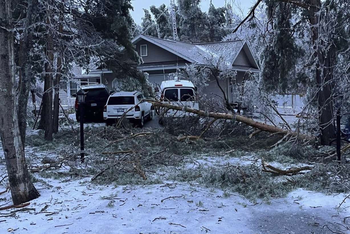
Hundreds of thousands of homes and businesses were without power in the eastern half of the Midwest as of Monday morning. Most of the outages were in Michigan, which along with Wisconsin has seen snow and ice accumulate on power lines and trees.
March has already delivered an extraordinary number of tornado reports, surpassing the number from the same time last year. Some of the same regions struck by deadly storms earlier this month could once again find themselves in harm's way.
Fresh wave of tornadoes and extreme weather
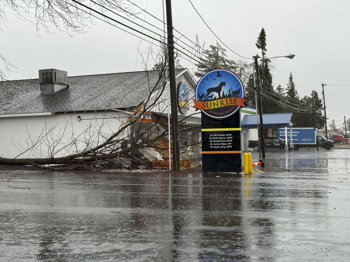
Tornadoes were reported Sunday in Arkansas, Missouri and Michigan. Tornado watches and warnings were also in effect overnight in parts of Tennessee, Mississippi and Alabama.
A possible tornado caused damage in McEwen, Tennessee, a town about 50 miles west of Nashville, according to CNN affiliate WSMV. The roof was torn off at least one home in the McEwen area. The homeowners were trapped inside but were not injured, the county sheriff told WSMV.
Photos from the Oklahoma City area late Saturday showed hailstones ranging from about the size of a quarter to a golf ball, many of them spiked.
Much of the intense storms were expected to strike after nightfall, heightening concerns. Tornadoes that occur at night are nearly twice as likely to be fatal as those during daylight hours, a 2022 study found.
Heavy rain could fall across some regions from the South to the Midwest, raising the risk of flash flooding.
In Florida, a mid-level storm system moved eastward Sunday afternoon, bringing flooding to Pensacola and Miami. Police in North Miami Beach reported flooding in multiple areas early Sunday evening.
Lights out across five states as storms continue Monday
Around a half a million homes and businesses were without power in Michigan, Wisconsin, Indiana, Ohio and Kentucky as of early Monday, according to PowerOutage.us. The vast majority of the outages were in Michigan, where more than 300,000 were in the dark.

Up to half an inch of ice accumulated on power lines and trees in northern Michigan. To the south in the state's Kalamazoo County, officials were juggling more than 130 reports of storm damage "and rapidly counting," the sheriff's office said on Facebook late Sunday. More trees weakened by the high winds and drenched soil are likely to fall, the sheriff warned, urging residents to treat any downed wires as live and dangerous.
The wintry mix in the Great Lakes area was expected to taper off heading into Monday, but a new threat is on the way for midweek. Northern Minnesota could see 4 to 8 inches of snow combined with 35 mph winds Tuesday evening through late Wednesday.
The immediate threat of storms will move eastward through the day Monday, reaching the East Coast from the Carolinas to the Mid-Atlantic by evening.
In addition to the wind and hail threat, these storms could produce localized flooding as some of them will train — or move across the same areas — repeatedly.
While some storms may briefly weaken with the morning light, they are expected to regain strength by the afternoon.
By Monday evening, the severe weather threat will span nearly the entire East Coast, placing nearly 100 million people at risk. Cities from New Orleans to Boston fall within the affected zone, though the specific threats will vary.
The Northeast's primary threat will be damaging wind gusts. A huge swath of the South, from the Mid-Atlantic to the Gulf Coast, will face the full spectrum of severe weather hazards, including hail, tornadoes and strong winds.
The storms are expected to linger overnight from the Mid-Atlantic to the Northeast before moving into the Atlantic Ocean by Tuesday.
A historic March for tornado activity
This year has already seen an extraordinary number of tornadoes, with approximately 300 tornado reports logged since January, nearly double the 164 reported by this time last year. Since 2010, only three years — 2023, 2017 and 2013 — have recorded more tornadoes in the first three months of the year.
Last year, tornado activity surged in late spring and persisted through December, resulting in nearly 2,000 tornado reports. It was the second-most tornado reports in a single year, surpassed only by 2017.
This spring's procession of severe storm systems looks likely to continue. With this week's threat looming, forecasters are already monitoring a large area from Texas to the Midwest for another potential round of thunderstorms on Wednesday.
Residents across all affected regions are urged to stay informed and have multiple ways to receive weather alerts, especially in areas at risk for nighttime storms.

Photos

Show All 11 Photos