Estimated read time: 4-5 minutes
- Washington County Commissioners urge residents to reduce water use and pray for rain.
- Southern Utah faces drought and below-normal snowpack, posing water availability challenges.
- Utah's reservoirs remain stable, but water conservation is crucial for future resilience.
ST. GEORGE — Washington County Commissioners are calling on residents to continue to reduce water consumption and pray for rain as Utah water managers say a mix of below-normal soil moisture and snowpack could create "challenges" in certain regions like southwest Utah.
"We encourage all residents to continue efforts to reduce their water use. The most effective way to reduce water use is to decrease landscape irrigation. In addition, we invite our citizens to join us in praying for the precipitation needed to meet the water demands of our community," Washington County Commissioners wrote, likening the current situation to the "faith, perseverance and courage" pioneers had when settling in the region.
"Today, we find ourselves in a similar moment of need," they added. "As we face an extended period of drought, we are reminded of our dependence on the Lord's provision and the power of unified prayer and fasting."
A divided snowpack
Utah's statewide snowpack is down to 90% of the median average for mid-January statewide, having slid backward as a quieter pattern in storm activity emerged after a run of storms between late December and early January hoisted it closer to average.
However, the divide between regions continues to grow. The Great Salt Lake Basin's snowpack remains at 98%, with snowpack levels between 93% and 108% across Utah's northern half on Friday. Some parts of central Utah are listed between 74% and 89%, but many southern Utah basins have fallen to 65% or worse.
That, mixed with drought and "abnormally dry" conditions, could cause problems, said Candice Hasenyager, director of the Utah Division of Water Resources.
"The dry soil moisture in southern Utah combined with below-normal snowpack could pose challenges for water availability in certain basins," she said, in an update to state water conditions on Thursday.
About 95% of the state's water supply comes from the snowpack collection and spring snowmelt process. Southwest Utah is in the roughest shape when it comes to drought and snowpack.
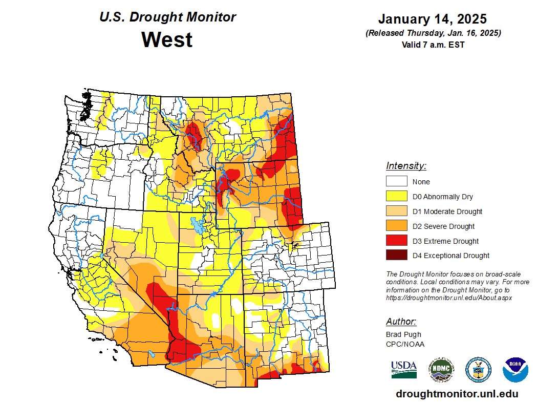
The Washington County Commissioners' statement came as St. George entered its 50th straight day without precipitation. It also went 78 days without rain between spring and early summer last year. A little more than half of Washington County has fallen into severe drought, while the rest is listed in moderate drought, according to the U.S. Drought Monitor.
Meanwhile, the Natural Resources Conservation Service reports that the southwestern Utah snowpack basin has only collected 1.5 inches of snow water equivalent so far this season, which is 27% of its median average for this point in the year and 0.1 inches off its lowest mid-January point since the 1980s.
La Niña's impact
The region isn't alone in its woes. Southwest Utah's drought represents the northeast section of a much larger drought within the American Southwest, which has also brought severe and extreme drought to parts of Arizona, California, Nevada and New Mexico.

Those areas just haven't received the same level of precipitation as the Pacific Northwest and northern Utah because of how the La Niña oceanic pattern has shaken out so far this winter, KSL meteorologist Matt Johnson explained. Northern Utah and, at times, central Utah have served as the southern end of the storm track over the past few weeks, which is fairly common for a La Niña winter.
"It's a desert climate and a more arid area, but even for their dry standards, it's way below that," he said, pointing to the Southwest drought. "We've got to get a complete pattern switch to change that."
Long-range outlooks offer some hope for southern Utah. All parts of the state have slightly higher odds for above-normal precipitation toward the final week of January, according to the National Weather Service's Climate Prediction Center.
However, the center also lists southern Utah as having slightly higher odds of below-normal precipitation in February and for the next three months. Many other parts of the state are listed as having "equal chances," which largely means they could still receive storm activity here and there.
Utah's savings account
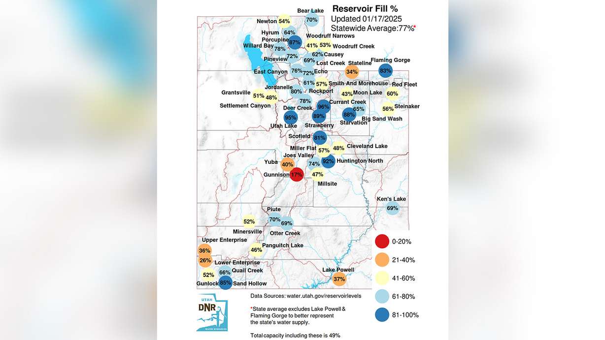
The good news statewide is Utah reservoir levels remain at 77% capacity, about the same level as last year and well above the normal for January.
"We're encouraged to see most reservoirs at or above normal levels for this time of year, even in areas with below-normal snowpack," Hasenyager said.

Even in southwest Utah, Sand Hallow Reservoir remains 85% full, while Quail Creek Reservoir is 66% full, according to the Utah Division of Water Resources. However, experts say other reservoirs in the region and state could struggle to refill if conditions persist as they have so far.
The Colorado Basin River Forecast Center projects that southern Utah may only receive 40% of its snowpack average this year after the snowpack runoff, while other parts of the state could fall into the 70%-90% range. That's why Hasenyager said it's important to conserve water as much as possible, just in case conditions don't improve.
"Every drop saved today contributes to a more resilient water supply tomorrow," she said. "Runoff efficiency will depend on weather conditions, but we all have a role to play in protecting this precious resource."


