- The National Weather Service issued a winter weather advisory for Utah's southern mountains.
- Up to a foot of snow is expected near Brian Head by early Monday.
- The storm is expected to bring valley rain and mountain snow across the state, as well.
SALT LAKE CITY — The National Weather Service has issued a winter weather advisory for parts of Utah's mountains, ahead of a storm that will snap a dry stretch that has already delayed the openings for the state's ski season.
The alert, issued Saturday morning, states that up to a foot of snow is possible in the southern mountains, while the agency adds that all of Utah's mountains could receive a healthy accumulation.
It follows a warm stretch that was one for the record books. Record high temperatures were reported across the Wasatch Front and Tooele Valley, as well as parts of central and northern Utah. Those types of temperatures will eventually cool down
Storm timing
The advisory is tied to a low-pressure system coming in from the Pacific, which has delivered multiple inches of precipitation in southern California.
It will play into Utah's weather this weekend and into early next week, but — much like most of the Western storm activity over the past few weeks — it's a cutoff low-pressure system, which can be difficult to forecast the exact path or strength of the system.
Some small showers popped up around southwest Utah and in parts of the state's mountains on Friday, but weather models project that storm activity will pick up in southwest Utah by Saturday evening. The precipitation will continue moving north toward other parts of the state by early Sunday, delivering a mix of valley rain and mountain snow, said KSL meteorologist Kevin Eubank.
"(There'll be) valley rain (and) some high-elevation snow throughout the day Sunday, and then the piece goes to the north on Monday," he said. "We still have clouds and a slight chance (for precipitation) in northern Utah. Same story over in southern Utah — just some scattered rain, but it opens the door for a pretty stormy first half of the week."
Additional showers are possible later in the week.
Potential accumulations
The winter weather advisory states that 6 to 12 inches of snow or more is possible in areas above 9,000 feet elevation across the southern mountains by early Monday, and 2 to 6 inches in slightly lower-elevation areas. It affects communities like Alton and Brian Head.
🏔️❄️ Mountain snow arrives late Saturday night across the high elevations of southern Utah. Most accumulating snow will be confined to areas above 9000 feet with snow levels dropping as low as 7000 feet by late Sunday. This will persist through early Monday morning. #utwxpic.twitter.com/ezoI6W60HH
— NWS Salt Lake City (@NWSSaltLakeCity) November 14, 2025
A National Weather Service snow forecast model suggests Brian Head could end up with over a foot of snow by early Tuesday. It comes as the resort has already postponed its opening day twice because of the lack of snow. The forecast offers hope that it will be able to operate on Nov. 21, its new scheduled opening date.
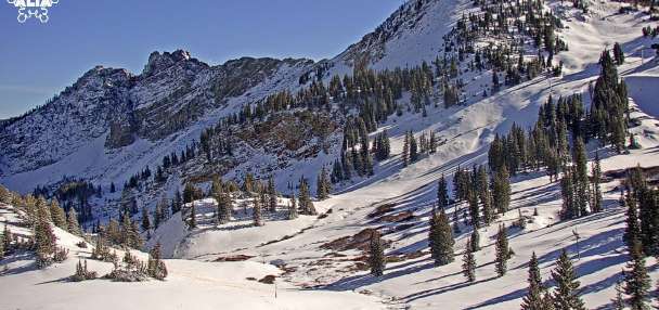
While exact totals might be difficult to project, the National Weather Service also projects that parts of the Wasatch Mountains, including Alta, could receive a half-foot of snow.
Meanwhile, updated KSL Weather models show the storm could deliver a half-inch of rain or more across southwestern and southeastern Utah communities by late Sunday. Lesser amounts are expected along the Wasatch Front and northern Utah.
High temperatures are expected to remain in the mid-60s across the Wasatch Front on Saturday, before sliding back into the mid-to-upper 50s on Sunday and Monday.
More to come?
After a record-setting October, this month has been quite dry. Salt Lake City has only collected a trace of rain after receiving 5.12 inches of precipitation last month — its fifth-wettest month ever.
Yet, long-range models suggest the incoming storm could open the door for more storm activity as Utah enters the second half of the month.
There's still a chance of showers in the forecast through Wednesday, while all parts of the state have slightly elevated odds of above-normal precipitation over the next two weeks, according to the National Weather Service Climate Prediction Center.
Utah could be in for a wet Thanksgiving as part of it.
It'll help Utah's resorts finally launch in time for the holidays, should the forecast come to fruition.
Full seven-day forecasts for areas across Utah can be found online at the KSL Weather Center.