Estimated read time: Less than a minute
This archived news story is available only for your personal, non-commercial use. Information in the story may be outdated or superseded by additional information. Reading or replaying the story in its archived form does not constitute a republication of the story.
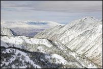
SALT LAKE CITY — The Utah Avalanche Center has issued a backcountry avalanche warning until 6 a.m. Monday after the Wasatch Front saw high snowfall totals over the past week.
The center says avalanche danger is high today for the central and southern Wasatch range, including the western Uintas.
The warning advises Utahns to stay “off and out from under slopes steeper than 30 degrees.”
According to the National Weather Service, Utah’s mountains saw several feet of snow over the course of the week. Since 5 p.m. Tuesday, Solitude recorded 48 inches, Snowbird had 39 and Park City Mountain saw 24.
Related Story
Snowfall ends in most of Utah after week of storms
Snowfall continued Saturday morning along the Wasatch Front after a week of storms that created treacherous travel conditions over the Thanksgiving holiday.In addition to “high” avalanche danger ratings in the Uintas, Salt Lake and Provo, the Logan, Ogden, Skyline, Moab and Abajos areas all have “considerable” avalanche danger as well.